Back Pireneë Afrikaans Pyrenäen ALS ፒሬኔ ተራሮች Amharic Pireneu AN Pireni ANG البرانس Arabic البرانس ARZ Pirineos AST Pireney dağları Azerbaijani پیرنه داغلاری AZB
| The Pyrenees Mountains | |
|---|---|
| Spanish: Pirineos French: Pyrénées Catalan: Pirineus Aragonese: Pirineus Occitan: Pirenèus Basque: Pirinioak, Auñamendiak | |
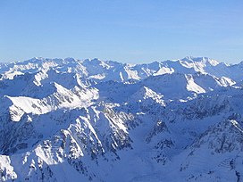
 Central Pyrenees | |
| Highest point | |
| Peak | Aneto |
| Elevation | 3,404 m (11,168 ft) |
| Coordinates | 42°37′56″N 00°39′28″E / 42.63222°N 0.65778°E |
| Dimensions | |
| Length | 491 km (305 mi) |
| Area | 55,000 km2 (21,000 sq mi) |
| Naming | |
| Etymology | Named for Pyrene |
| Geography | |
| Countries | |
| Range coordinates | 42°40′N 1°00′E / 42.667°N 1.000°E |
| Geology | |
| Rock ages | |
| Rock types | |
The Pyrenees[1] are a mountain range straddling the border of France and Spain. They extend nearly 500 km (310 mi) from their union with the Cantabrian Mountains to Cap de Creus on the Mediterranean coast, reaching a maximum altitude of 3,404 metres (11,168 ft) at the peak of Aneto.[2]
For the most part, the main crest forms a divide between Spain and France, with the microstate of Andorra sandwiched in between. Historically, the Crown of Aragon and the Kingdom of Navarre extended on both sides of the mountain range.[3][4]
- ^ (/pɪrɪˈniːz/ pirr-in-EEZ; Spanish: Pirineos [piɾiˈneos]; French: Pyrénées [piʁene] ; Catalan: Pirineus [piɾiˈnɛws]; Basque: Pirinioak [piɾini.o.ak]; Occitan: Pirenèus [piɾeˈnɛws]; Aragonese: Pirineus)
- ^ Barnolas, A. y Pujalte, V. (2004). «La Cordillera Pirenaica». Vera Torres, J. A. (ed.), ed. Geología de España. Sociedad Geológica de España e Instituto Geológico y Minero de España. pp. 231-343. ISBN 84-7840-546-1.
- ^ Preamble of the "Charter of the Catalan Language" Archived 2009-03-25 at the Wayback Machine
- ^ Collins Road Atlas of Europe. London: Harper Collins. 1995. pp. 28–29. ISBN 0-00-448148-8.
