Back جزيرة راساى ARZ Ratharsair Breton Raasay Catalan Isle of Raasay CEB Raasay Czech Raasay German Ράσεϊ Greek Raasay Spanish Raasay Basque Raasay French
| Scottish Gaelic name | Ratharsair |
|---|---|
| Pronunciation | [ˈrˠa.arˠs̪əɾʲ] |
| Old Norse name | Raa-s-oy or Ross-oy, Rásey or Hrossey |
| Meaning of name | Old Norse for "roe deer island" or possibly "horse island" |
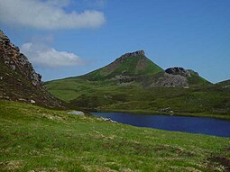
 Dùn Caan from Loch na Mna | |
| Location | |
| OS grid reference | NG579395 |
| Coordinates | 57°24′N 6°02′W / 57.400°N 6.033°W |
| Physical geography | |
| Island group | Skye |
| Area | 6,231 ha (24 sq mi) |
| Area rank | 19 [1] |
| Highest elevation | Dùn Caan 444 m (1,457 ft) |
| Administration | |
| Council area | Highland |
| Country | Scotland |
| Sovereign state | United Kingdom |
| Demographics | |
| Population | 161[2] |
| Population rank | 38 [1] |
| Population density | 2.5/km2 (6.5/sq mi)[2][3] |
| Largest settlement | Inverarish |
| References | [4][5] |
Raasay (/ˈrɑːseɪ/; Scottish Gaelic: Ratharsair[6]), sometimes the Isle of Raasay,[5] is an island between the Isle of Skye and the mainland of Scotland. It is separated from Skye by the Sound of Raasay and from Applecross by the Inner Sound. It is famous for being the birthplace of Gaelic poet Sorley MacLean, an important figure in the Scottish Renaissance.[7]
Traditionally the home of Clan MacSween, the island was ruled by the MacLeods from the 15th to the 19th century. Subsequently, a series of private landlords held title to the island, which is now largely in public ownership.[8] Raasay House, which was visited by James Boswell and Samuel Johnson in 1773, is now a hotel, restaurant, bar and outdoor activity centre.[9] Raasay means "Isle of the Roe Deer" and the island is home to an endemic subspecies of bank vole.[3]
- ^ a b Area and population ranks: there are c. 300 islands over 20 ha in extent and 93 permanently inhabited islands were listed in the 2011 census.
- ^ a b National Records of Scotland 2013.
- ^ a b Haswell-Smith 2004.
- ^ Haswell-Smith 2004, pp. 161–166.
- ^ a b Ordnance Survey. OS Maps Online (Map). 1:25,000. Leisure.
- ^ Mac an Tàilleir 2003.
- ^ Gifford, Dunnigan & MacGillivray 2002.
- ^ Keay & Keay 1994.
- ^ Raasay House 2016.
