Back منطقة رايشور Arabic رايشور ARZ रायचूर जिला Bihari রায়চুর জেলা Bengali/Bangla Districte de Raichur Catalan Raichur (distrito sa Indiya) CEB Raichur (Distrikt) German Distrito de Raichur Spanish Raichur barrutia Basque بخش رایچور Persian
Raichur district | |
|---|---|
 | |
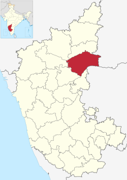
 Location in Karnataka | |
| Coordinates: 16°13′N 77°21′E / 16.21°N 77.35°E | |
| Country | |
| State | Karnataka |
| Division | Gulbarga |
| Headquarters | Raichur |
| Talukas | Raichur, Sindhanur, Lingsugur, Manvi, Devadurga, Sirwar, Maski |
| Government | |
| • District collector | Chandrashekhar L. Nayaka (IAS) |
| Area † | |
| • Total | 8,386 km2 (3,238 sq mi) |
| Elevation | 400.0 m (1,312.3 ft) |
| Population (2011) | |
| • Total | 1,928,812 |
| • Density | 230/km2 (600/sq mi) |
| Languages | |
| • Official | Kannada |
| Time zone | UTC+5:30 (IST) |
| PIN | 584101,584102,584103 |
| Telephone code | 08532 |
| ISO 3166 code | IN-KA-RA |
| Vehicle registration | KA-36 |
| Sex ratio | 0.983 ♂/♀ |
| Literacy | 48.8% |
| Lok Sabha constituency | Raichur Lok Sabha constituency |
| Precipitation | 680.6 millimetres (26.80 in) |
| Website | raichur |
Raichur District is an administrative district in the Indian state of Karnataka. It is located in the northeast part of the state and is bounded by Yadgir district in the north, Bijapur and Bagalkot district in the northwest, Koppal district in the west, Bellary district in the south, Jogulamba Gadwal district of Telangana and Kurnool district of Andhra Pradesh in the east.
