Back Раменскан кӀошт CE Ramenskiy Rayon CEB Раменск районĕ CV Ramenskij rajon Danish Ramenskoje rajoon Estonian ناحیه رامنسکی Persian Ռամենսկի շրջան Armenian Ramenskij rajon Italian Раменской буе MYV Rejon ramieński Polish
Ramensky District
Раменский район | |
|---|---|
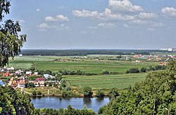
 Borovky Kurgan, Ramensky District | |
 Location of Ramensky District in Moscow Oblast (before July 2012) | |
| Coordinates: 55°34′N 38°13′E / 55.567°N 38.217°E | |
| Country | Russia |
| Federal subject | Moscow Oblast[1] |
| Administrative center | Ramenskoye[1] |
| Area | |
| • Total | 1,397.46 km2 (539.56 sq mi) |
| Population | |
| • Total | 256,375 |
| • Density | 180/km2 (480/sq mi) |
| • Urban | 56.8% |
| • Rural | 43.2% |
| Administrative structure | |
| • Administrative divisions | 1 Towns, 5 Work settlements and suburban settlements, 15 Rural settlements |
| • Inhabited localities[4] | 1 cities/towns, 5 Urban-type settlements[5], 232 rural localities |
| Municipal structure | |
| • Municipally incorporated as | Ramensky Municipal District[2] |
| • Municipal divisions[2] | 6 urban settlements, 15 rural settlements |
| Time zone | UTC+3 (MSK |
| OKTMO ID | 46648000 |
| Website | http://www.ramenskoye.ru/ |
Ramensky District (Russian: Ра́менский райо́н) is an administrative[1] and municipal[2] district (raion), one of the thirty-six in Moscow Oblast, Russia. It is located in the southeastern central part of the oblast. The area of the district is 1,397.46 square kilometers (539.56 sq mi).[2] Its administrative center is the town of Ramenskoye.[1] Population: 256,375 (2010 Census);[3] 217,939 (2002 Census);[7] 153,215 (1989 Soviet census).[8] The population of Ramenskoye accounts for 66.2% of the district's total population.[3]
| Year | Pop. | ±% |
|---|---|---|
| 1939 | 160,795 | — |
| 1970 | 151,630 | −5.7% |
| 1979 | 150,626 | −0.7% |
| 1989 | 153,215 | +1.7% |
| 2002 | 217,939 | +42.2% |
| 2010 | 256,375 | +17.6% |
| 2021 | 331,584 | +29.3% |
| Source: Census data | ||
The cities of Zhukovsky and Bronnitsy with localities under their jurisdictions, while surrounded by the district's territory, are administratively and municipally separate from it (Zhukovsky since 1952 and Bronnitsy since 1992).
- ^ a b c d Law #11/2013-OZ
- ^ a b c d e Law #55/2005-OZ
- ^ a b c Russian Federal State Statistics Service (2011). Всероссийская перепись населения 2010 года. Том 1 [2010 All-Russian Population Census, vol. 1]. Всероссийская перепись населения 2010 года [2010 All-Russia Population Census] (in Russian). Federal State Statistics Service.
- ^ Resolution #123-PG
- ^ The count of urban-type settlements may include the work settlements, the resort settlements, the suburban (dacha) settlements, as well as urban-type settlements proper.
- ^ "Об исчислении времени". Официальный интернет-портал правовой информации (in Russian). June 3, 2011. Retrieved January 19, 2019.
- ^ Federal State Statistics Service (May 21, 2004). Численность населения России, субъектов Российской Федерации в составе федеральных округов, районов, городских поселений, сельских населённых пунктов – районных центров и сельских населённых пунктов с населением 3 тысячи и более человек [Population of Russia, Its Federal Districts, Federal Subjects, Districts, Urban Localities, Rural Localities—Administrative Centers, and Rural Localities with Population of Over 3,000] (XLS). Всероссийская перепись населения 2002 года [All-Russia Population Census of 2002] (in Russian).
- ^ Всесоюзная перепись населения 1989 г. Численность наличного населения союзных и автономных республик, автономных областей и округов, краёв, областей, районов, городских поселений и сёл-райцентров [All Union Population Census of 1989: Present Population of Union and Autonomous Republics, Autonomous Oblasts and Okrugs, Krais, Oblasts, Districts, Urban Settlements, and Villages Serving as District Administrative Centers]. Всесоюзная перепись населения 1989 года [All-Union Population Census of 1989] (in Russian). Институт демографии Национального исследовательского университета: Высшая школа экономики [Institute of Demography at the National Research University: Higher School of Economics]. 1989 – via Demoscope Weekly.

