Rarh
Rāḍha | |
|---|---|
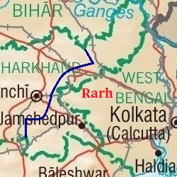
 Map showing the area of Rarh | |
| Coordinates: 23°15′N 87°04′E / 23.25°N 87.07°E | |
| Country | |
| Region | East India |
| Government | |
| • Body | Government of West Bengal, Government of Jharkhand |
| Language | |
| • Dialect | Rarhi dialect |
| Languages | |
| • Official | Bengali |
| • Other languages | Santhali, Kudmali |
| Time zone | UTC+5:30 (IST) |
| Vehicle registration | WB-11,WB-12,WB-14,WB-15,WB-16,WB-18,WB-29,
WB-30,WB-31,WB-32,WB-33,WB-34,WB-36,WB-37, WB-38,WB-39,WB-40,WB-41,WB-42,WB-44,WB-53, WB-54,WB-55,WB-56,WB-57,WB-WB-58,WB-67, WB-68[citation needed] |
| Major Cities | Asansol, Durgapur, Bardhaman, Bankura, Howrah, Nabadwip |
| Civic agency | Government of West Bengal |
Rarh region (Bengali pronunciation: [raːɽʱ]) is a toponym for an area in the Indian subcontinent that lies between the Chota Nagpur Plateau on the West and the Ganges Delta on the East. Although the boundaries of the region have been defined differently according to various sources throughout history, it is mainly coextensive with the state of West Bengal, also comprising parts of the state of Jharkhand in India.
The Rarh region historically has been known by many different names and has hosted numerous settlements throughout history. One theory identifies it with the powerful Gangaridai nation mentioned in the ancient Greco-Roman accounts. The Naihati copper plate inscription of King Ballal Sen names it as the ancestral settlement of the Sena dynasty.


