Back نهر راريتان Arabic نهر راريتان ARZ Raritan River CEB Raritan River German Raritan Estonian Raritan (fleuve) French נהר רריטאן HE Raritan (fiume) Italian Raritanas Lithuanian Raritan (rivier) Dutch
| Raritan River Rariton | |
|---|---|
 Raritan River as seen from Bridgewater Township, New Jersey | |
 | |
| Etymology | Raritan Indian tribe |
| Location | |
| Country | United States |
| State | New Jersey |
| Counties | Hunterdon, Mercer, Middlesex, Monmouth, Morris, Somerset, Union |
| Municipalities | Raritan, Clinton, Bridgewater Township, Somerville, Bound Brook, South Bound Brook, Piscataway, Franklin Township, New Brunswick, Highland Park, Edison, East Brunswick, Sayreville, Woodbridge, Perth Amboy, South Amboy |
| Physical characteristics | |
| Source | |
| • location | Confluence of South Branch Raritan River and North Branch Raritan River |
| • coordinates | 40°33′20″N 74°41′14″W / 40.55556°N 74.68722°W[1] |
| • elevation | 47.7 ft (14.5 m) |
| Mouth | |
• location | Raritan Bay |
• coordinates | 40°29′41″N 74°16′17″W / 40.49472°N 74.27139°W[1] |
• elevation | 0 ft (0 m) |
| Length | 69.6 mi (112.0 km) |
| Basin size | 1,100 sq mi (700,000 acres; 2,800 km2) |
| Width | |
| • average | 200 ft (61 m) |
| Depth | |
| • minimum | 9 ft (2.7 m) |
| • maximum | 25 ft (7.6 m) |
| Discharge | |
| • location | Bound Brook |
| • average | 1,070 cu ft/s (30 m3/s) |
| • minimum | 100 cu ft/s (2.8 m3/s) |
| • maximum | 10,800 cu ft/s (310 m3/s) |
| Basin features | |
| Population | ~1.2 million |
| Tributaries | |
| • left | Peters Brook, Cuckles Brook, Middle Brook, Green Brook, Mill Brook, Red Root Creek, Crows Mill Creek |
| • right | Dukes Brook, Millstone River, Fox Creek, Mile Run, Lawrence Brook, South River |
| Bridges | Victory Bridge, Edison Bridge, Driscoll Bridge, New Jersey Turnpike, U.S. Highway No. 1 Bridge, highway bridge over South River at the town of South River |
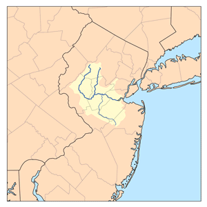
The Raritan River is a river of the U.S. state of New Jersey. Its watershed drains much of the central region of the state, emptying into the Raritan Bay near Staten Island on the Atlantic Ocean.