Back Laôt Mirah ACE Хыплъыжь ADY Rooisee Afrikaans Rotes Meer ALS ቀይ ባሕር Amharic Mar Roya AN Okwaan̄ Anyiaan̄ ANN البحر الأحمر Arabic ܝܡܐ ܣܘܡܩܐ ARC لبحر لحمر ARY
This article has multiple issues. Please help improve it or discuss these issues on the talk page. (Learn how and when to remove these messages)
|
| Red Sea | |
|---|---|
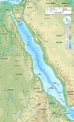
 Map of the Red Sea | |
| Location | North Africa, East Africa, and West Asia |
| Coordinates | 22°N 38°E / 22°N 38°E |
| Type | Sea |
| Primary inflows | Gulf of Aden, Gulf of Suez |
| Primary outflows | Bab-el-Mandeb, Suez Canal |
| Basin countries | |
| Max. length | 2,250 km (1,400 mi) |
| Max. width | 355 km (221 mi) |
| Surface area | 438,000 km2 (169,000 sq mi) |
| Average depth | 490 m (1,610 ft) |
| Max. depth | 3,040 m (9,970 ft) |
| Water volume | 233,000 km3 (56,000 cu mi) |
The Red Sea is a sea inlet of the Indian Ocean, lying between Africa and Asia. Its connection to the ocean is in the south, through the Bab-el-Mandeb strait and the Gulf of Aden. To its north lie the Sinai Peninsula, the Gulf of Aqaba, and the Gulf of Suez—leading to the Suez Canal. It is underlain by the Red Sea Rift, which is part of the Great Rift Valley.
The Red Sea has a surface area of roughly 438,000 km2 (169,000 sq mi),[1] is about 2,250 km (1,400 mi) long, and 355 km (221 mi) wide at its widest point. It has an average depth of 490 m (1,610 ft), and in the central Suakin Trough it reaches its maximum depth of 3,040 m (9,970 ft).[2]
Approximately 40% of the Red Sea is quite shallow at less than 100 m (330 ft) deep, and about 25% is less than 50 m (160 ft) deep. The extensive shallow shelves are noted for their marine life and corals. More than 1,000 invertebrate species and 200 types of soft and hard coral live in the sea. The Red Sea is the world's northernmost tropical sea, and has been designated a Global 200 ecoregion.
- ^ "State of the Marine Environment Report for the Red Sea and Gulf of Aden: 2006" (PDF). 16 June 2008. Archived (PDF) from the original on 21 April 2021. Retrieved 25 January 2020.
- ^ Dinwiddie, Robert (2008). Thomas, Louise (ed.). Ocean: The World's Last Wilderness Revealed. London: Dorling Kindersley. p. 452. ISBN 978-0-7566-2205-3.