Back مقاطعة رينولدز (ميزوري) Arabic Reynolds County, Missouri BAR Рейнолдс (окръг, Мисури) Bulgarian রেইনল্ডস কাউন্টি, মিসৌরি BPY Reynolds Gông (Missouri) CDO Рейнольдс (гуо, Миссури) CE Reynolds County CEB Reynolds County, Missouri Welsh Reynolds County German Condado de Reynolds Spanish
Reynolds County | |
|---|---|
 The antebellum county courthouse in Centerville | |
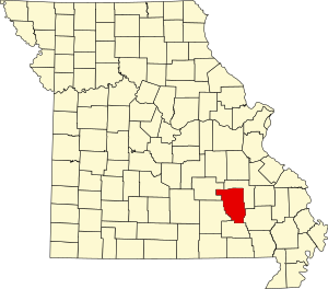
 Location within the U.S. state of Missouri | |
 Missouri's location within the U.S. | |
| Coordinates: 37°22′N 90°58′W / 37.36°N 90.97°W | |
| Country | |
| State | |
| Founded | February 25, 1845 |
| Named for | Thomas Reynolds |
| Seat | Centerville |
| Largest city | Ellington |
| Area | |
| • Total | 814 sq mi (2,110 km2) |
| • Land | 808 sq mi (2,090 km2) |
| • Water | 5.9 sq mi (15 km2) 0.7% |
| Population (2020) | |
| • Total | 6,096 |
| • Density | 7.5/sq mi (2.9/km2) |
| Time zone | UTC−6 (Central) |
| • Summer (DST) | UTC−5 (CDT) |
| Congressional district | 8th |
Reynolds County is a county located in the Ozark Foothills Region in the Lead Belt of Missouri. As of the 2020 census, the population was 6,096.[1] Its county seat is Centerville.[2] The county was officially organized on February 25, 1845, and was named in honor of former Governor of Missouri Thomas Reynolds.[3]
The county is home to Johnson's Shut-Ins State Park, a popular tourist attraction in the state of Missouri.
- ^ "Explore Census Data". data.census.gov. Retrieved December 20, 2021.
- ^ "Find a County". National Association of Counties. Retrieved June 7, 2011.
- ^ Eaton, David Wolfe (1917). How Missouri Counties, Towns and Streams Were Named. The State Historical Society of Missouri. pp. 347.