Back رینگوود، ویکتوریا Persian Ringwood, Bhictòria Scots/Gaelic Ringwood, Victoria Swedish 令伍特(维克多利亚) WUU 令伍特 (维多利亚州) Chinese
| Ringwood Melbourne, Victoria | |||||||||||||||
|---|---|---|---|---|---|---|---|---|---|---|---|---|---|---|---|
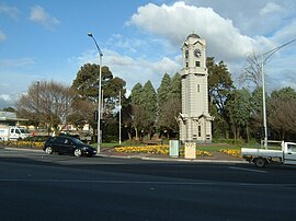
 Ringwood Clocktower | |||||||||||||||
 | |||||||||||||||
| Coordinates | 37°48′40″S 145°13′52″E / 37.811°S 145.231°E | ||||||||||||||
| Population | 19,144 (2021 census)[1] | ||||||||||||||
| • Density | 1,877/km2 (4,861/sq mi) | ||||||||||||||
| Postcode(s) | 3134 | ||||||||||||||
| Elevation | 123 m (404 ft) | ||||||||||||||
| Area | 10.2 km2 (3.9 sq mi)[2] | ||||||||||||||
| Location | 25 km (16 mi) E of Melbourne CBD (Central Melbourne) | ||||||||||||||
| LGA(s) | City of Maroondah | ||||||||||||||
| Region | Greater Melbourne | ||||||||||||||
| County | Mornington Evelyn | ||||||||||||||
| State electorate(s) | Ringwood | ||||||||||||||
| Federal division(s) | Deakin | ||||||||||||||
| |||||||||||||||
Ringwood is an eastern suburb of Melbourne, Victoria, Australia, 25 km (16 mi) east of Melbourne's Central Business District, located within the City of Maroondah local government area. Ringwood recorded a population of 19,144 at the 2021 census.[3]
Ringwood has many parks and reserves, most notably Ringwood Lake, an 8.5-hectare park is used for various recreational activities which includes a lake with bridge, sound shell, mining history display, playground, picnic shelters, barbecues and a bushland walking circuit.[4]
- ^ Australian Bureau of Statistics (28 June 2022). "Ringwood (Vic.) (Suburbs and Localities)". 2021 Census QuickStats. Retrieved 4 July 2022.
- ^ "Data by region | Australian Bureau of Statistics". dbr.abs.gov.au. Retrieved 18 April 2023.
- ^ "2021 Ringwood (Vic.), Census All persons QuickStats | Australian Bureau of Statistics". www.abs.gov.au. Retrieved 9 May 2023.
- ^ "Ringwood Lake Information Kit". Maroondah City Council. May 2005. Archived from the original on 6 June 2017. Retrieved 26 April 2013.
