Back Rio Negro Afrikaans ريو نيغرو (الأمازون) Arabic نهر نجرو ARZ Riu-Neqru (Amazon) Azerbaijani ریو نقرو (آمازون) چایی AZB Риу-Негру (йылға) Bashkir Рыу-Негру Byelorussian Рыў-Нэгру BE-X-OLD Рио Негро (приток на Амазонка) Bulgarian रियो नीग्रो (अमेजन) Bihari
This article includes a list of general references, but it lacks sufficient corresponding inline citations. (January 2010) |
| Rio Negro Guainía River | |
|---|---|
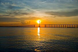
 Sunset over the Rio Negro, upstream from Manaus | |
 Map showing the Rio Negro in the Amazon Basin | |
| Native name |
|
| Location | |
| Countries | |
| Physical characteristics | |
| Source | highlands of Colombia |
| • location | Guainía Department, Amazon region, Colombia |
| • coordinates | 1°56′50″N 70°1′55″W / 1.94722°N 70.03194°W (approximately) |
| • elevation | 250 m (820 ft) (approximately) |
| Mouth | Amazon River |
• location | Manaus, Amazonas State, Brazil |
• coordinates | 3°08′00″S 59°54′30″W / 3.13333°S 59.90833°W |
• elevation | 8 m (26 ft)[1] |
| Length | Rio Negro–Guainía 2,250 km (1,400 mi)[2] |
| Basin size | 714,577.6 km2 (275,900.0 sq mi)[3] |
| Width | |
| • average | 2,450 m (8,040 ft)[4] |
| Depth | |
| • average | 20 m (66 ft) (Serrinha); 24 m (79 ft) to 31 m (102 ft) (Manaus)[3] |
| • maximum | 60 m (200 ft) (Manaus)[4] |
| Discharge | |
| • location | Manaus |
| • average | (Period: 2015–2019)34,573 m3/s (1,220,900 cu ft/s)[4] |
| • minimum | 4,240 m3/s (150,000 cu ft/s)[3] |
| • maximum | 64,380 m3/s (2,274,000 cu ft/s)[3] |
| Discharge | |
| • location | Paricatuba (Anavilhanas) |
| • average | (Period: 2008–2019)34,444 m3/s (1,216,400 cu ft/s)[5] |
| • minimum | 7,633 m3/s (269,600 cu ft/s) (2009/10)[5] |
| • maximum | 65,510 m3/s (2,313,000 cu ft/s) (2014/06)[5] |
| Discharge | |
| • location | Serrinha, 0°28′57.4716″S 64°49′36.6492″W / 0.482631000°S 64.826847000°W |
| • average | (Period: 1997–2015)16,845.5 m3/s (594,890 cu ft/s)[7] |
| • minimum | 5,000 m3/s (180,000 cu ft/s)[6] |
| • maximum | 30,000 m3/s (1,100,000 cu ft/s)[6] |
| Discharge | |
| • location | São Felipe, 0°22′11.8056″N 67°18′42.9948″W / 0.369946000°N 67.311943000°W |
| • average | (Period: 1997–2014)8,314.5 m3/s (293,620 cu ft/s)[7] |
| • minimum | 1,200 m3/s (42,000 cu ft/s)[6] |
| • maximum | 15,500 m3/s (550,000 cu ft/s)[6] |
| Discharge | |
| • location | Cucuí |
| • average | (Period: 1997–2014)5,113.1 m3/s (180,570 cu ft/s)[7] |
| • minimum | 400 m3/s (14,000 cu ft/s)[6] |
| • maximum | 10,500 m3/s (370,000 cu ft/s)[6] |
| Basin features | |
| Progression | Amazon → Atlantic Ocean |
| River system | Amazon River |
| Tributaries | |
| • left | Casiquiare, Cauaburi, Marauiá, Macucuaú, Padauari, Demini, Jufari, Branco, Jauaperi, Camanaú, Baependi, Apuaú, Cuieiras, Tarumã Mirim, Tarumã Açu |
| • right | Guainía (Upper Negro), Xié, Içana, Uaupés, Curicuriari, Marié, Tea, Uneiuxi, Aiuanã, Urubaxi, Ararirá, Cuiuni, Caurés, Unini, Jaú, Puduari |
The Rio Negro (Portuguese: Rio Negro [ˈʁi.u neɡɾu]; Spanish: Río Negro [ˈri.o ˈneɣɾo] "Black River"), or Guainía as it is known in its upper part, is the largest left tributary of the Amazon River (accounting for about 14% of the water in the Amazon basin), the largest blackwater river in the world,[8] and one of the world's ten largest rivers by average discharge. Despite its high flow, the Rio Negro has a low sediment load (5.76 million tonnes per year on average in Manaus).[4]
- ^ Tannenbaum, Frank (29 August 2012). TEN KEYS LAT AMER. Knopf Doubleday Publishing Group. ISBN 9780307826565. Retrieved 9 April 2018 – via Google Books.
- ^ Ziesler, R.; Ardizzone, G.D. (1979). "Amazon River System". The Inland waters of Latin America. Food and Agriculture Organization of the United Nations. ISBN 92-5-000780-9. Archived from the original on 8 November 2014.
- ^ a b c d "Amazon basin water resources observation service".
- ^ a b c d Rogério Ribeiro, Marinho; Naziano Filizola, Junior; Jean Michel, Martinez; Tristan, Harmel (2022). "Suspended sediment transport estimation in Negro River (Amazon Basin) using MSI/Sentinel-2 data". Revista Brasileira de Geomorfologia. 23. doi:10.20502/rbg.v23i1.2076.
- ^ a b c d e f Juan Gabriel, Leon; Stèphane, Calmont; F., Seyler; Marie-Paule, Bonnet; Mathilde, Cauhopé; Frédéric, Frappart; Naziano, Filizola; Pascal, Fraizy (2010). "Rating curves and estimation of average water depth at the upper Negro River based on satellite altimeter data and modeled discharges". Journal of Hydrology. 328 (3–4): 481–496. doi:10.1016/J.JHYDROL.2005.12.006.
- ^ a b c Jamie, Towner (2019). "Assessing the performance of global hydrological models for capturing peak river flows in the Amazon basin" (PDF).
- ^ "Waters". Amazon Waters. 28 May 2014. Retrieved 10 October 2017.