| River Bourne | |
|---|---|
 The River Bourne enters the Medway | |
 | |
| Physical characteristics | |
| Source | |
| • location | Ightham. TQ 597 567 |
| • coordinates | 51°17′13″N 0°17′28″E / 51.2869°N 0.2911°E |
| • elevation | 249 feet (76 m) |
| Mouth | |
• location | River Medway, East Peckham. TQ 664 477 |
• coordinates | 51°12′15″N 0°22′59″E / 51.2042°N 0.3830°E |
• elevation | 42 feet (13 m) |
| Length | 10-mile (16 km) |

River Bourne mills | |||||||||||||||||||||||||||||||||||||||||||||||||||||||||||||||||||||||||||||||||||||||||||||||||||||||||||||||||||||||||||||||||||||||||||||||||||||||||||||||||
|---|---|---|---|---|---|---|---|---|---|---|---|---|---|---|---|---|---|---|---|---|---|---|---|---|---|---|---|---|---|---|---|---|---|---|---|---|---|---|---|---|---|---|---|---|---|---|---|---|---|---|---|---|---|---|---|---|---|---|---|---|---|---|---|---|---|---|---|---|---|---|---|---|---|---|---|---|---|---|---|---|---|---|---|---|---|---|---|---|---|---|---|---|---|---|---|---|---|---|---|---|---|---|---|---|---|---|---|---|---|---|---|---|---|---|---|---|---|---|---|---|---|---|---|---|---|---|---|---|---|---|---|---|---|---|---|---|---|---|---|---|---|---|---|---|---|---|---|---|---|---|---|---|---|---|---|---|---|---|---|---|---|
| |||||||||||||||||||||||||||||||||||||||||||||||||||||||||||||||||||||||||||||||||||||||||||||||||||||||||||||||||||||||||||||||||||||||||||||||||||||||||||||||||
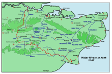
The River Bourne rises in the parish of Ightham, Kent and flows in a generally south easterly direction through the parishes of Borough Green, Platt, Plaxtol, West Peckham, Hadlow, and East Peckham where it joins the River Medway. In the 18th century the river was known as the Busty or Buster, the Shode or Sheet, but is not known by these names nowadays. A bourne is a type of stream, while shode means a branch of a river.[1]
It gives its name to the Bourne ward in Tonbridge and Malling Borough.[2]
- ^ Coles Finch, William (1933). Watermills & Windmills. London WC1: C W Daniel Company. p. 36.
{{cite book}}: CS1 maint: location (link) - ^ Mapit https://mapit.mysociety.org/area/167007.html
