Back نهر كالدير (نهر) ARZ Río Calder Spanish Calder (Yorkshire de l'Ouest) French Calder (West Yorkshire) Italian Calder NN Calder NB Calder (West Yorkshire) Polish Rio Calder Portuguese Calder, West Yorkshire Serbo-Croatian River Calder SIMPLE
| Calder | |
|---|---|
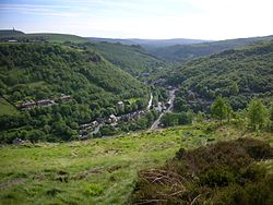
 View of the Calder Valley west of Hebden Bridge | |
 | |
| Location | |
| Country | England |
| Metropolitan County | West Yorkshire |
| Towns/Cities | Todmorden, Hebden Bridge, Sowerby Bridge, Elland, Brighouse, Mirfield, Dewsbury, Wakefield |
| Physical characteristics | |
| Source | Heald Moor |
| • location | between Holme Chapel and Cornholme, Lancashire |
| • elevation | 1,312 ft (400 m) |
| Mouth | |
• location | River Aire, Castleford |
| Length | 45 mi (72 km) |
The River Calder is a river in West Yorkshire, in Northern England.
The Calder rises on Heald Moor in Lancashire close to the source of another river with the same name, and then flows east into West Yorkshire through green countryside, former woollen-mill villages and towns before joining the River Aire near Castleford.
The river's valley is generally known as the Calder Valley. The name Calderdale usually refers to the large urban and rural borough (centred on Halifax) through which the upper river flows. The lower reaches flow through the boroughs of Kirklees (based on Huddersfield) and Wakefield. However, the river does not flow through the centres of Halifax and Huddersfield, which are on the Calder's main tributaries, Hebble Brook and the River Colne respectively. The only large town centres through which the Calder flows are Brighouse, Mirfield, Dewsbury and the city of Wakefield.
The river itself is only navigable in short sections, but these sections are connected by artificial "cuts" (e.g. Horbury Cut) to form the Calder and Hebble Navigation, a popular leisure waterway which is part of the connected inland waterway network of England and Wales.