Back نهر دي (ويلز) Arabic نهر دى ARZ Dee (Wales) BAR Dyfrdwy Breton Dee (Gal·les) Catalan River Dee (suba sa Hiniusang Gingharian, Inglatera, Metropolitan Borough of Wirral) CEB Ди (Ирланди тинĕсне кĕрет) CV Afon Dyfrdwy Welsh Dee (Wales) Danish Dee (Wales) German
| River Dee | |
|---|---|
 River Dee at Llangollen | |
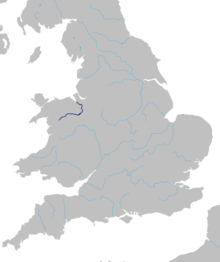
 Map of the route of the River Dee in Wales and England | |
| Native name | Afon Dyfrdwy (Welsh) |
| Location | |
| Country | England and Wales |
| Cities | Chester |
| Physical characteristics | |
| Source | |
| • location | slopes of Dduallt above Llanuwchllyn, Snowdonia, Wales |
| • coordinates | 52°49′56″N 3°45′56″W / 52.8322°N 3.7656°W |
| • elevation | 450 m (1,480 ft) |
| Mouth | Dee Estuary |
• coordinates | 53°21′14″N 3°13′33″W / 53.3539°N 3.2258°W |
• elevation | 0 m (0 ft) |
| Length | 113 km (70 mi) |
| Basin size | 1,816.8 km2 (701.5 sq mi) |
| Discharge | |
| • location | Chester Weir |
| • average | 29.71 m3/s (1,049 cu ft/s) |
| Discharge | |
| • location | Manley Hall |
| • average | 31.03 m3/s (1,096 cu ft/s) |
| Discharge | |
| • location | Bala Lake |
| • average | 13.06 m3/s (461 cu ft/s) |
| Basin features | |
| Tributaries | |
| • left | Tryweryn, Alwen, Clywedog, Alyn |
| • right | Ceiriog, Wych Brook |
The River Dee (Welsh: Afon Dyfrdwy, Latin: Deva Fluvius) is a river flowing through North Wales, and through Cheshire, England, in Great Britain. The length of the main section from Bala to Chester is 113 km (70 miles) and it is largely located in Wales. The stretch between Aldford and Chester is within England, and two other sections form the border between the two countries.[1]
The river rises on Dduallt in Snowdonia and flows east through Bala Lake, Corwen, and Llangollen. It turns north near Overton-on-Dee and forms part of the England–Wales border before fully entering England north-east of Wrexham. It flows through Chester then re-enters Wales; the final section is canalised and discharges to the Irish Sea via an estuary 23 km (14 miles) long.
- ^ Chisholm, Hugh, ed. (1911). . Encyclopædia Britannica. Vol. 7 (11th ed.). Cambridge University Press. p. 921.