Back نهر سپى ARZ Spè Breton Riu Spey Catalan River Spey (suba sa Hiniusang Gingharian) CEB Spey Czech Спей (юханшыв) CV Afon Spey Welsh Spey German Río Spey Spanish Spey ibaia Basque
| River Spey | |
|---|---|
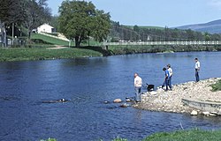
 The River Spey at Aberlour | |
 | |
| Location | |
| Country | Scotland |
| State | United Kingdom |
| Physical characteristics | |
| Source | Loch Spey |
| • location | Roybridge, Scotland |
| • coordinates | 57°00′26″N 4°36′18″W / 57.00729°N 4.60499°W |
| • elevation | 349 m (1,145 ft) |
| Mouth | Moray Firth, Spey Bay |
• location | Fochabers, Scotland |
• coordinates | 57°40′34″N 3°06′00″W / 57.676°N 3.100°W |
• elevation | 0 m (0 ft) |
| Length | 98 mi (158 km) |
| Basin size | 3,008 km2 (1,161 sq mi)[1] |
| Discharge | |
| • average | 64 m3/s (2,300 cu ft/s)[1] |
| Basin features | |
| Designation | |
| Official name | River Spey - Insh Marshes |
| Designated | 2 February 1997 |
| Reference no. | 889[2] |
 | |
The River Spey (Scottish Gaelic: Uisge Spè) is a river in the northeast of Scotland. At 98 mi (158 km)[3] it is the eighth longest river in the United Kingdom and the second longest[4] and fastest-flowing river in Scotland. (The Tay is the longest with the Clyde third in Scotland.[4] It is an important location for the traditions of salmon fishing and whisky production in Scotland.
- ^ a b "Spey Fishery Board". Archived from the original on 22 February 2007. Retrieved 21 August 2006.
- ^ "River Spey - Insh Marshes". Ramsar Sites Information Service. Retrieved 25 April 2018.
- ^ Clayton, Phil (2012). Headwaters: Walking to British River Sources (First ed.). London: Frances Lincoln Limited. p. 207. ISBN 9780711233638.
- ^ a b Almanac of Scotland Retrieved 9 April 2024.