Back نهر تيست ARZ River Test CEB Test ibaia Basque رود تست Persian Test (joki) Finnish Test (fleuve) French テスト川 Japanese Test (rivier) Dutch Test (rzeka) Polish Test Serbo-Croatian
| River Test | |
|---|---|
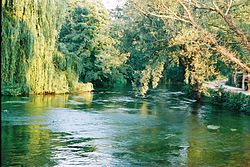
 The Test downstream of Sadler's Mill, Romsey | |
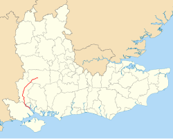
 River Test highlighted in red, shown in South East England | |
| Location | |
| Country | England |
| Counties | Hampshire |
| Physical characteristics | |
| Source | |
| • location | Ashe, near Overton, Hampshire, United Kingdom |
| • coordinates | 51°14′43″N 1°14′21″W / 51.2454°N 1.2392°W |
| • elevation | 90 m (300 ft) |
| Mouth | Southampton Water |
• location | Southampton, Hampshire |
• coordinates | 50°55′30″N 1°28′45″W / 50.9251°N 1.4792°W |
• elevation | 0 m (0 ft) |
| Length | 64 km (40 mi) |
| Width | |
| • minimum | 1 m (3 ft 3 in) |
| • average | 20 m (66 ft) |
| • maximum | 56 m (184 ft) |
| Depth | |
| • minimum | 0.5 m (1 ft 8 in) |
| • average | 2 m (6 ft 7 in) |
| • maximum | 4 m (13 ft) |
| Basin features | |
| Tributaries | |
| • left | River Blackwater, River Dun, Wallop Brook, River Anton, Pilhill Brook |
| • right | River Dever, Bourne Rivulet, River Swift |
| Site of Special Scientific Interest | |
 River Test at Tufton | |
| Grid reference | SU 384 355[1] |
| Interest | Biological |
| Area | 438.0 hectares (1,082 acres)[1] |
| Notification | 1996[1] |
| Location map | Magic Map |
The River Test is a chalk stream in Hampshire in the south of England. It rises at Ashe near Basingstoke and flows southwards for 40 miles (64 km) to Southampton Water. Settlements on the Test include the towns of Stockbridge and Romsey. The river's valley gives its name to the local government district of Test Valley. Below the village of Longparish, the river is broadly followed by the Test Way, a long-distance footpath.[2]
Much of the Test is a 438-hectare (1,080-acre) biological Site of Special Scientific Interest.[1][3] It is part of the Solent and Southampton Water Ramsar site[4] and Special Protection Area.[5] The river is used for fly fishing for trout from its source to its tidal limit.[6]
- ^ a b c d "Designated Sites View: River Test". Sites of Special Scientific Interest. Natural England. Retrieved 18 May 2020.
- ^ "The Test Way". Hampshire County Council. Retrieved 7 September 2020.
- ^ "Map of River Test". Sites of Special Scientific Interest. Natural England. Retrieved 18 May 2020.
- ^ "Designated Sites View: Solent and Southampton Water". Ramsar Site. Natural England. Retrieved 23 April 2020.
- ^ "Designated Sites View: Solent and Southampton Water". Special Protection Areas. Natural England. Retrieved 23 April 2020.
- ^ Environment Agency (2006). Fact file on the River Test. Retrieved 8 February 2006. Archived 8 April 2005 at the Wayback Machine