Back نهر يار ARZ Yare Breton River Yare (suba sa Hiniusang Gingharian, lat 52,60, long 1,75) CEB Yare Czech Yare (Fluss) German Yare (rivière) French Abhainn Yare Irish Yare Italian Yare NN Yare NB
| Yare | |
|---|---|
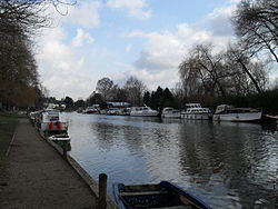
 The river at Thorpe Green, Norwich | |
| Location | |
| Country | England |
| Region | Norfolk |
| Physical characteristics | |
| Source | |
| • location | west of Shipdham |
| • coordinates | 52°37′11″N 0°50′19″E / 52.6196°N 0.8386°E |
| • elevation | 79 m (259 ft) |
| Mouth | Breydon Water |
• location | Burgh Castle |
• coordinates | 52°35′17″N 1°38′33″E / 52.58798°N 1.64262°E |
• elevation | 0 m (0 ft) |
| Length | 83.5 km (51.9 mi) |
| Basin features | |
| River system | River Wensum |
River Yare | ||||||||||||||||||||||||||||||||||||||||||||||||||||||||||||||||||||||||||||||||||||||||||||||||||||||||||||||||||||||||||||||||||||||||||||||||||||||||||||||||||||||||||||||||||||||||||||||||||||||||||||||||||||||||||||||||||||||||||||||||||||||||||||||||||||||||||||||||||||||||||||||||||||||||||||||||||||||||||||||||||||||||||||||||||||||||||||||
|---|---|---|---|---|---|---|---|---|---|---|---|---|---|---|---|---|---|---|---|---|---|---|---|---|---|---|---|---|---|---|---|---|---|---|---|---|---|---|---|---|---|---|---|---|---|---|---|---|---|---|---|---|---|---|---|---|---|---|---|---|---|---|---|---|---|---|---|---|---|---|---|---|---|---|---|---|---|---|---|---|---|---|---|---|---|---|---|---|---|---|---|---|---|---|---|---|---|---|---|---|---|---|---|---|---|---|---|---|---|---|---|---|---|---|---|---|---|---|---|---|---|---|---|---|---|---|---|---|---|---|---|---|---|---|---|---|---|---|---|---|---|---|---|---|---|---|---|---|---|---|---|---|---|---|---|---|---|---|---|---|---|---|---|---|---|---|---|---|---|---|---|---|---|---|---|---|---|---|---|---|---|---|---|---|---|---|---|---|---|---|---|---|---|---|---|---|---|---|---|---|---|---|---|---|---|---|---|---|---|---|---|---|---|---|---|---|---|---|---|---|---|---|---|---|---|---|---|---|---|---|---|---|---|---|---|---|---|---|---|---|---|---|---|---|---|---|---|---|---|---|---|---|---|---|---|---|---|---|---|---|---|---|---|---|---|---|---|---|---|---|---|---|---|---|---|---|---|---|---|---|---|---|---|---|---|---|---|---|---|---|---|---|---|---|---|---|---|---|---|---|---|---|---|---|---|---|---|---|---|---|---|---|---|---|---|---|---|---|---|---|---|---|---|---|---|---|---|---|---|---|---|---|---|---|---|---|---|---|---|---|---|---|---|---|---|---|---|---|---|---|
| ||||||||||||||||||||||||||||||||||||||||||||||||||||||||||||||||||||||||||||||||||||||||||||||||||||||||||||||||||||||||||||||||||||||||||||||||||||||||||||||||||||||||||||||||||||||||||||||||||||||||||||||||||||||||||||||||||||||||||||||||||||||||||||||||||||||||||||||||||||||||||||||||||||||||||||||||||||||||||||||||||||||||||||||||||||||||||||||
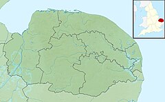
The River Yare is a river in the English county of Norfolk. In its lower reaches it is one of the principal navigable waterways of The Broads and connects with the rest of the network.
The river rises south of Dereham to the west to the village of Shipdham. Above its confluence with a tributary stream from Garvestone it is known as the Blackwater River.[1] From there it flows in a generally eastward direction passing Barnham Broom and is joined by the River Tiffey before reaching Bawburgh. It then skirts the southern fringes of the city of Norwich, passing through Colney, Cringleford, Lakenham and Trowse. At Whitlingham it is joined by the River Wensum and although the Wensum is the larger and longer of the two, the river downstream of their confluence continues to be called the Yare. Flowing eastward into The Broads it passes the villages of Bramerton, Surlingham, Rockland St. Mary and Cantley. Just before Reedham at Hardley Cross (erected in 1676[2]) it is joined by the River Chet. The cross marks the ancient boundary between the City of Norwich and Borough of Great Yarmouth. Beyond Reedham the river passes the famously isolated marshland settlement of Berney Arms before entering the tidal lake of Breydon Water. Here the Yare is joined by the Rivers Waveney and Bure and finally enters the North Sea at Gorleston, Great Yarmouth.[3][4]
The Yare is the frequent subject of landscape paintings by members of the early 19th century Norwich School of artists. The National Gallery of Art in Washington D.C. contains an oil painting by John Crome entitled Moonlight on the Yare. Joseph Stannard depicted the river in Thorpe Water Frolic, Afternoon (1824) and Boats on the Yare near Bramerton (1828) which is in the Fitzwilliam Museum, Cambridge.
The river is navigable to small coastal vessels from Norwich to the sea, and in former times carried significant commercial traffic to that city. At Reedham the river is joined by the Haddiscoe Cut, a canal which provides a direct navigable link to the River Waveney at Haddiscoe avoiding Breydon Water.
- ^ Ordnance Survey of Great Britain
- ^ Norwich Boundary Crosses Archived 2006-10-13 at the Wayback Machine
- ^ Ordnance Survey (2005). OS Explorer Map OL40 - The Broads. ISBN 0-319-23769-9.
- ^ Ordnance Survey (1999). OS Explorer Map 237 - Norwich. ISBN 0-319-21868-6.
