Back Раанок (востраў) Byelorussian Illa de Roanoke Catalan Roanoke Island CEB Roanoke Island German Roanoke Esperanto Isla de Roanoke Spanish Île Roanoke French Roanoke sziget Hungarian Pulau Roanoke ID Isola di Roanoke Italian
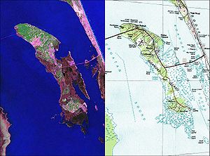
 Maps of Roanoke Island taken from the U.S Geological Survey and the U.S Department of the Interior and NASA. | |
| Geography | |
|---|---|
| Location | Atlantic Ocean |
| Coordinates | 35°53′20″N 75°39′40″W / 35.889°N 75.661°W |
| Area | 17.95 sq mi (46.5 km2) |
| Administration | |
United States | |
| State | North Carolina |
| Demographics | |
| Population | 6,724 (2000) |
Roanoke Island (/ˈroʊənoʊk/) is an island in Dare County, bordered by the Outer Banks of North Carolina. It was named after the historical Roanoke, a Carolina Algonquian people who inhabited the area in the 16th century at the time of English colonization.
About 8 miles (13 km) long and 2 miles (3.2 km) wide, the island lies between the mainland and the barrier islands near Nags Head. Albemarle Sound lies on its north, Roanoke Sound on the eastern, Croatan Sound on the west, and Wanchese CDP lies at the southern end. The town of Manteo is located on the northern portion of the island, and is the county seat of Dare County. Fort Raleigh National Historic Site is on the north end of the island. The island has a land area of 17.95 square miles (46.5 km2) and a population of 6,724 as of the 2000 census.
Today U.S. Highway 64, a major highway, connects mainland North Carolina to the Outer Banks, as well as Roanoke Island. The island has recreational and water features, plus historical sites and an outdoor theater that form one of the major tourist attractions of Dare County.
The residents of Roanoke Island are governed by the Dare County Board of Commissioners. They are located within North Carolina's 1st congressional district.

