Back Rotsgebergte Afrikaans Rocky Mountains ALS ሮኪ ተራሮች Amharic Montanyas Rocosas AN جبال روكي Arabic جبال روكى ARZ ৰকি পৰ্বতমালা Assamese Montes Rocosos AST Кьурахарал мугӀрул AV रॉकी पर्वत AWA
| Rocky Mountains | |
|---|---|
| The Rockies (en), Les montagnes Rocheuses (fr), Montañas Rocosas, Rocallosas (es) | |
 Moraine Lake and the Valley of the Ten Peaks, Banff National Park, Alberta, Canada | |
| Highest point | |
| Peak | Mount Elbert |
| Elevation | 14,440 feet (4401.2 m)[1] |
| Coordinates | 39°07′03.9″N 106°26′43.2″W / 39.117750°N 106.445333°W |
| Dimensions | |
| Length | 4,828 km (3,000 mi)(straight-line distance) |
| Area | 777,000 km2 (300,000 sq mi)[2] |
| Geography | |
| Countries |
|
| Provinces/States | |
| Range coordinates | 43°44′28″N 110°48′07″W / 43.741°N 110.802°W |
| Parent range | North American Cordillera |
| Geology | |
| Rock ages |
|
| Rock types | |
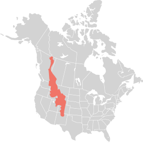
The Rocky Mountains, also known as the Rockies, are a major mountain range and the largest mountain system in North America. The Rocky Mountains stretch 3,000 miles (4,800 kilometers)[3] in straight-line distance from the northernmost part of Western Canada, to New Mexico in the Southwestern United States. Depending on differing definitions between Canada and the U.S., its northern terminus is located either in northern British Columbia's Terminal Range south of the Liard River and east of the Trench, or in the northeastern foothills of the Brooks Range/British Mountains that face the Beaufort Sea coasts between the Canning River and the Firth River across the Alaska-Yukon border.[4] Its southernmost point is near the Albuquerque area adjacent to the Rio Grande rift and north of the Sandia–Manzano Mountain Range. Being the easternmost portion of the North American Cordillera, the Rockies are distinct from the tectonically younger Cascade Range and Sierra Nevada, which both lie farther to its west.
The Rockies formed 55 million to 80 million years ago during the Laramide orogeny, in which a number of plates began sliding underneath the North American plate.[citation needed] The angle of subduction was shallow, resulting in a broad belt of mountains running down western North America.[citation needed] Since then, further tectonic activity and erosion by glaciers have sculpted the Rockies into dramatic peaks and valleys. At the end of the last ice age, humans began inhabiting the mountain range. After explorations of the range by Europeans, such as Sir Alexander Mackenzie, and Anglo-Americans, such as the Lewis and Clark Expedition, natural resources such as minerals and fur drove the initial economic exploitation of the mountains, although the range itself never experienced a dense population.
Most of the highest summits of the Rocky Mountains are in Colorado, with that state having an average elevation in excess of 2,000 metres (6,600 ft). Public parks and forest lands protect much of the mountain range, and they are popular tourist destinations, especially for hiking, camping, mountaineering, fishing, hunting, mountain biking, snowmobiling, skiing, and snowboarding.
- ^ "MOUNT ELBERT". NGS Data Sheet. National Geodetic Survey, National Oceanic and Atmospheric Administration, United States Department of Commerce. 2019. Retrieved June 20, 2023.
- ^ "Rocky Mountains, or Rockies". Encyclopædia Britannica Kids.
- ^ "Rocky Mountains | Location, Map, History, & Facts". Encyclopedia Britannica. Retrieved July 2, 2020.
- ^ Cite error: The named reference
Geologywas invoked but never defined (see the help page).
