Back ساغاميهارا (كاناغاوا) Arabic ساجاميهارا, كاناجاوا ARZ Saqamihara Azerbaijani ساقامیهارا، کاناقاوا AZB Сагаміхара Byelorussian Сагамихара Bulgarian Sagamihara Breton Sagamihara Catalan Сагамихара CE Sagamihara-shi CEB
Sagamihara
相模原市 | |
|---|---|
| Sagamihara City | |
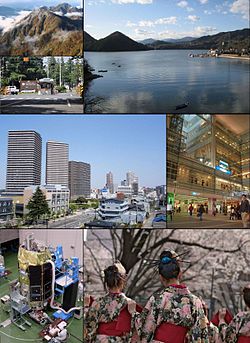
 From top left: Tanzawa mountains, USARJ Sagami General Depot, Lake Sagami, Hashimoto District, Odakyu Sagami-Ōno Station, JAXA Sagamihara Campus, Sakura Festival | |
 | |
 Location of Sagamihara in Kanagawa Prefecture | |
| Coordinates: 35°34′N 139°22′E / 35.567°N 139.367°E | |
| Country | Japan |
| Region | Kantō |
| Prefecture | Kanagawa |
| First official recorded | 110 AD |
| City settled | November 20, 1954 |
| Government | |
| • Mayor | Kentarō Motomura (since April 2019) |
| Area | |
| • Total | 328.91 km2 (126.99 sq mi) |
| Population (May 1, 2021) | |
| • Total | 723,470 |
| • Density | 2,200/km2 (5,700/sq mi) |
| Time zone | UTC+9 (Japan Standard Time) |
| – Tree | Zelkova serrata |
| – Flower | Hydrangea |
| – Bird | Skylark |
| Phone number | 042-754-1111 |
| Address | 2-11-15 Chūō, Chūō-ku, Sagamihara-shi, Kanagawa-ken 252-5277 |
| Website | Official website |


Sagamihara (相模原市, Sagamihara-shi) is a city in Kanagawa Prefecture, Japan. As of 1 May 2021[update], the city has an estimated population of 723,470, with 334,812 households,[1] and a population density of 1,220 persons per km2. The total area of the city is 328.91 square kilometres (126.99 sq mi).[2] Sagamihara is the third-most-populous city in the prefecture, after Yokohama and Kawasaki, and the fifth most populous suburb of the Greater Tokyo Area. Its northern neighbor is Machida, with which a cross-prefectural merger has been proposed.[3]
On April 1, 2010, the city became the 19th city designated by government ordinance. As a result of this, three wards were established: Midori-ku, Chūō-ku and Minami-ku.
- ^ "Sagamihara city official statistics" (in Japanese). Japan.
- ^ "Overview of Sagamihara City" (in Japanese). Japan: Sagamihara City. Retrieved May 5, 2017.
- ^ Merger proposal (in Japanese) (Translate to English: Google, Bing, Yandex)


