Back سانت-لوران (مونتريال) Arabic Saint-Laurent ATJ Saint-Laurent (bahin nga lungsod) CEB Saint-Laurent (Montreal) German Saint-Laurent (Montreal) Spanish Saint-Laurent Estonian Saint-Laurent (Montréal) French Saint-Laurent (Québec) Italian Saint-Laurent (dzielnica) Polish Saint-Laurent (Quebec) Portuguese
Saint-Laurent | |
|---|---|
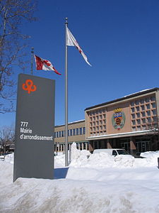
 Saint-Laurent borough hall. | |
 Location on the Island of Montreal. (Dark grey areas indicate demerged municipalities). | |
| Coordinates: 45°30′07″N 73°42′25″W / 45.502°N 73.707°W | |
| Country | |
| Province | |
| Region | Montréal |
| Established | January 1, 2002 |
| Electoral Districts Federal | Saint-Laurent |
| Provincial | Saint-Laurent and Acadie |
| Government | |
| • Type | Borough |
| • Mayor | Alan DeSousa (EM) |
| • Federal MP(s) | Emmanuella Lambropoulos (LPC) |
| • Quebec MNA(s) | Marwah Rizqy (PLQ) Christine St-Pierre (PLQ) |
| Area | |
| • Land | 42.8 km2 (16.5 sq mi) |
| Population | |
| • Total | 98,828 |
| • Density | 2,310.7/km2 (5,985/sq mi) |
| • Pop 2011-2016 | |
| • Dwellings | 37,370 |
| Time zone | UTC−5 (EST) |
| • Summer (DST) | UTC−4 (EDT) |
| Postal code(s) | |
| Area code(s) | (514) and (438) |
| Highways | |
| Website | https://montreal.ca/en/saint-laurent |
Saint-Laurent (French pronunciation: [sɛ̃ lɔʁɑ̃] ) is a borough of the city of Montreal, Canada, located in the northern part of the island. Although it is no longer an independent city, it is still commonly known as Ville Saint-Laurent (City of Saint-Laurent) or by its initials, VSL.
Saint-Laurent is the largest of Montreal's boroughs by land area. Its population was 98,828 inhabitants in 2016.
- ^ "PROFIL SOCIODÉMOGRAPHIQUE. Recensement 2016. Arrondissement de Saint-Laurent. Édition mai 2018" (PDF). Ville de Montréal.
