| Salmon River | |
|---|---|
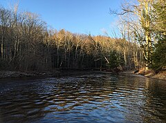
 Looking downstream on the Salmon River immediately after the confluence of the Jeremy and Blackledge Rivers. | |
 | |
| Location | |
| Country | United States |
| State | Connecticut |
| Cities | Colchester, East Hampton, East Haddam, Haddam |
| Physical characteristics | |
| Source confluence | confluence of Blackledge River and Jeremy River |
| • location | Colchester, New London County, Connecticut |
| Mouth | confluence with Connecticut River |
• location | East Haddam & Haddam, Middlesex County |
| Length | 10.4 mi (16.7 km) |
| Basin size | 150 sq mi (390 km2) |
| Basin features | |
| Tributaries | |
| • left | Day Pond Brook, Moodus River |
| • right | Dickinson Creek, Flat Brook, Safstrom Brook, Elbow Brook, Pine Brook |
The Salmon River is formed at the confluence of the Blackledge and Jeremy rivers about one mile west of North Westchester, Connecticut. It drains 96,000 acres[1] and courses for 10.4 miles (16.7 km)[2] to Salmon Cove near Moodus where it flows into the Connecticut River. The Salmon River is probably the largest stream and watershed whose sources and mouth are entirely within the limits of Connecticut.[3]
There is a popular paddling route along the Salmon River varying in difficulty from quickwater to Class II whitewater. It begins along River Road about 1/10 of a mile south of the river's formation and continues for about 7 miles to the flatwater of Salmon Cove.
The Salmon River's substantial drop in elevation over its course provided considerable water power to the textile mills in Moodus during the 19th and early 20th centuries.
- ^ "Why Protect the Watershed". Salmon River Watershed Partnership. Salmon River Watershed Partnership. Retrieved 30 January 2016.
- ^ U.S. Geological Survey. National Hydrography Dataset high-resolution flowline data. The National Map, accessed April 1, 2011
- ^ "Salmon River State Forest". State Parks and Forests. Connecticut Department of Energy and Environmental Protection. Retrieved July 24, 2014.
