Back San Juan de Los Morros AN San Juan de los Morros Aymara San Juan de los Morros CEB San Juan de los Morros German San Juan de los Morros Spanish سن خوان د لاس موروس Persian San Juan de los Morros Finnish San Juan de Los Morros (Venezuela) French Սան Խուան դե լոս Մոռոս Armenian San Juan de los Morros Italian
This article needs additional citations for verification. (October 2023) |
San Juan de los Morros | |
|---|---|
City | |
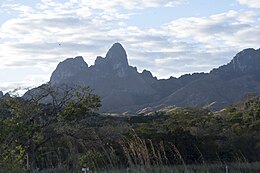
San Juan de los Morros panoramic view, the San Juan Bautista Statue and the Morros de San Juan | |
| Coordinates: 09°54′39″N 67°21′29″W / 9.91083°N 67.35806°W | |
| Country | |
| State | Guárico |
| Municipality | Juan Germán Roscio Municipality |
| Founded | 26 May 1780 |
| Founded by | Mariano Martí |
| Elevation | 428.5 m (1,405.8 ft) |
| Population | |
| • Total | 120,111 [1] |
| Demonym | Sanjuanero/a |
| Time zone | UTC−4 (VET) |
| postal code | 2301 |
| area code | 0246 |
| Climate | Aw |
San Juan de los Morros (Spanish pronunciation: [saŋ ˈxwan de los ˈmoros]) is the capital city of Guárico State, located in Venezuela. The city is commonly referred to as the "Gateway to the Central Plains" (Puerta a Los Llanos Centrales). Having a geography in which majestic mountains prevail, the capital city's population is 120,111, [2] (taken from the 2011 census), being the second most populated city in Guárico State, after Calabozo, and is the state's first in population density.
It was one of the first cities founded in Guárico State, along with Calabozo, Valle de la Pascua, and Zaraza. Among the primary landmarks of the city are the Monument to the Flag, the mountain range Arístides Rojas (known as Morros de San Juan), the Monument to San Juan Bautista, El Platillón hill, the monument to the Beata Guariqueña, Madre Candelaria de San José, La Villa Olímpica, and the thermal waters (baños termales), which have great significance in the city due to the medicinal properties of its sulphuric waters (that is, because of the amount of sulphur that its waters possess): such is its effectiveness and fame, that from ancient times, once he became President of Venezuela, Antonio Guzmán Blanco, constructed the first highway to the city, which grants entry to this restoration supply that his own circle of relative physician had recommended.
San Juan de los Morros has a weather of 24 to 32 °C and its remedy is ruled via way of means of mountains, which evaluation with the plains of the relaxation of the state.[2]
Guárico is the fourth largest state in the country in terms of area, but not in population, as it has a low population density. San Juan de los Morros used to be part of Aragua State, but it was changed during the 1930s to Guárico State, and the city was later named state capital, replacing the former capital, Ortiz.
Among the major features of the city are the Statue of San Juan Bautista (John the Baptist) which is 19.8 meters (62,3 ft) high, the Bandera Monument, the Bolivar Square, 'Los Morros de San Juan' monument, the historic place and monument known as "La Puerta" (The Gate), and the hot springs. The medicinal sulfuric content of the springs makes them a significant tourist attraction.
San Juan de Los Morros has a climate of 24 to 32 degrees Celsius and is dominated by surrounding mountains, which contrasts with the plains of the rest of the state. Typical dishes that originate from the Guarico area are: the cachapa, the pabellón criollo (Venezuela's typical dish), and arepas (a type of corn griddle cake).
The city is connected to the south with Parapara and Ortiz by a national highway. It is served by the Guarico Municipal Airport.
- ^ Data get from [1]
- ^ a b "XIV CENSO NACIONAL DE POBLACION Y VIVIENDA" (PDF). December 2014.


