Back سان ماتيو (كاليفورنيا) Arabic سان ماتيو (كاليفورنيا) ARZ San-Mateo (Kaliforniya) Azerbaijani سان ماتئو، کالیفورنیا AZB County San Mateo, California BAN Сан-Матэа (Каліфорнія) Byelorussian Сан Матео Bulgarian San Mateo (Califòrnia) Catalan Сан-Матео (Калифорни) CE San Mateo (lungsod sa Tinipong Bansa, California) CEB
San Mateo | |
|---|---|
|
Top: aerial view of San Mateo; middle: downtown (left) and Draper University (right); bottom: downtown (left) and Bay Meadows (right) | |
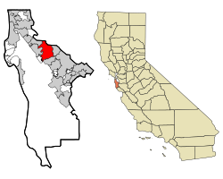
 Location in San Mateo County and the state of California | |
| Coordinates: 37°33′15″N 122°18′47″W / 37.55417°N 122.31306°W | |
| Country | United States |
| State | California |
| County | San Mateo |
| Incorporated | September 4, 1894[1] |
| Named for | St. Matthew |
| Government | |
| • Mayor | Lisa Diaz Nash[2] |
| • City manager | Alex Khojikian[3] |
| Area | |
| • Total | 15.85 sq mi (41.04 km2) |
| • Land | 12.13 sq mi (31.42 km2) |
| • Water | 3.71 sq mi (9.62 km2) 23.63% |
| Elevation | 46 ft (14 m) |
| Population | |
| • Total | 105,661 |
| • Rank | 73rd in California 317th in the United States |
| • Density | 8,711/sq mi (3,363/km2) |
| Time zone | UTC−8 (Pacific) |
| • Summer (DST) | UTC−7 (PDT) |
| ZIP Codes[7] | 94401–94404, 94497 |
| Area code | 650 |
| FIPS code | 06-68252 |
| GNIS feature IDs | 1659584, 2411800 |
| Website | www |
San Mateo (Spanish for 'Saint Matthew') (/ˌsæn məˈteɪoʊ/ SAN mə-TAY-oh) is the most populous city in the county of the same name, on the San Francisco Peninsula. About 20 miles (32 km) south of San Francisco, the city borders Burlingame to the north, Hillsborough to the west, San Francisco Bay and Foster City to the east and Belmont to the south. The population was 105,661 at the 2020 census.[6]
San Mateo has a Mediterranean climate and is known for its rich history at the center of the San Francisco Bay Area. Some of the biggest economic drivers for the city include technology, health care and education.[9]
- ^ "California Cities by Incorporation Date" (Word). California Association of Local Agency Formation Commissions. Retrieved January 13, 2017.
- ^ "City Council Special Meeting". San Mateo, CA. Retrieved December 12, 2022.
- ^ "Office of the City Manager". San Mateo, CA. Retrieved April 11, 2018.
- ^ "2019 U.S. Gazetteer Files". United States Census Bureau. Retrieved July 1, 2020.
- ^ "San Mateo". Geographic Names Information System. United States Geological Survey, United States Department of the Interior. Retrieved December 3, 2014.
- ^ a b "San Mateo (city) QuickFacts". United States Census Bureau.
- ^ "ZIP Code(tm) Lookup". United States Postal Service. Retrieved December 3, 2014.
- ^ "Population and Housing Unit Estimates". United States Census Bureau. May 24, 2020. Retrieved May 27, 2020.
- ^ Cite error: The named reference
:2was invoked but never defined (see the help page).


