Back Sandeg, Orcanege ANG Sanday CEB Sanday (Orkneje) Czech Sanday Welsh Sanday German Σάντι Greek Sanday (Orkadak) Basque Sanday (Orcades) French Sanndaigh, Arcaibh Scots/Gaelic Sanday (isole Orcadi) Italian
| Scots name | Sandee[1] |
|---|---|
| Old Norse name | Sandey[2][3] |
| Meaning of name | Old Norse: sand island[4] |
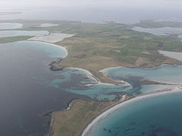
 An aerial view of the southern coast of Sanday, looking west. Tres Ness and Conninghole are in the foreground. | |
| Location | |
| OS grid reference | HY677411 |
| Coordinates | 59°15′N 2°33′W / 59.25°N 2.55°W |
| Physical geography | |
| Island group | Orkney |
| Area | 5,043 ha (19.5 sq mi)[4] |
| Area rank | 21 [6] |
| Highest elevation | The Wart 65 m (213 ft)[5] |
| Administration | |
| Council area | Orkney Islands |
| Country | Scotland |
| Sovereign state | United Kingdom |
| Demographics | |
| Population | 494[7] |
| Population rank | 22 [6] |
| Population density | 9.8 people/km2[4][7] |
| Largest settlement | Kettletoft |
| References | [8] |
Sanday (/ˈsændiː/, Scots: Sandee) is one of the inhabited islands of Orkney that lies off the north coast of mainland Scotland. With an area of 50.43 km2 (19.5 sq mi),[4] it is the third largest of the Orkney Islands.[9] The main centres of population are Lady Village and Kettletoft. Sanday can be reached by Orkney Ferries or by plane (Sanday Airport) from Kirkwall on the Orkney Mainland. On Sanday, an on-demand public minibus service allows connecting to the ferry.
- ^ "Map of Scotland in Scots - Guide and gazetteer" (PDF).
- ^ Orkney Placenames Archived 30 August 2000 at the Wayback Machine. Orkneyjar. Retrieved 15 November 2014.
- ^ Anderson (1873) p. 176.
- ^ a b c d Haswell-Smith (2004) p. 392
- ^ Ordnance Survey. OS Maps Online (Map). 1:25,000. Leisure. Retrieved 21 August 2013.
- ^ a b Area and population ranks: there are c. 300 islands over 20 ha in extent and 93 permanently inhabited islands were listed in the 2011 census.
- ^ a b National Records of Scotland (15 August 2013). "Appendix 2: Population and households on Scotland's Inhabited Islands" (PDF). Statistical Bulletin: 2011 Census: First Results on Population and Household Estimates for Scotland Release 1C (Part Two) (PDF) (Report). SG/2013/126. Retrieved 14 August 2020.
- ^ Pedersen, Roy (January 1992). Orkneyjar ok Katanes (map, Inverness, Nevis Print)
- ^ Haswell-Smith (2004) p. 334.
