Back مقاطعة سانتا كروز (كاليفورنيا) Arabic سانتا كروز كاونتى (كاليفورنيا) ARZ Santa-Kruz qraflığı (Kaliforniya) Azerbaijani Santa Cruz County, Kalifornien BAR Санта-Круз (акруга, Каліфорнія) Byelorussian Санта Крус (окръг, Калифорния) Bulgarian সান্তা ক্রুজ কাউন্টি, ক্যালিফোর্নিয়া BPY Comtat de Santa Cruz Catalan Санта-Круз (гуо, Калифорни) CE Santa Cruz County (kondado sa Tinipong Bansa, California) CEB
Santa Cruz County, California | |
|---|---|
| County of Santa Cruz | |
|
Images, from top down, left to right: The Santa Cruz Beach Boardwalk in 2005, a walkway through redwood groves in Big Basin Redwoods State Park, the Roaring Camp and Big Trees Narrow Gauge Railroad in 2008, Downtown Watsonville in 2010, Davenport Beach in 2006 | |
 Interactive map of Santa Cruz County | |
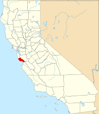
 Location in the state of California | |
| Coordinates: 37°02′N 122°01′W / 37.03°N 122.01°W | |
| Country | United States |
| State | California |
| Region | Central Coast |
| CSA | San Jose-San Francisco-Oakland |
| Incorporated | February 18, 1850[1] |
| Named for | Mission Santa Cruz and the city of Santa Cruz, both named after the Exaltation of the Cross |
| County seat | Santa Cruz |
| Largest city | Santa Cruz |
| Government | |
| • Type | Council–CAO |
| • Body | Board of Supervisors |
| • Chair | Zach Friend |
| • Vice Chair | Justin Cummings |
| • Board of Supervisors[2] | Supervisors
|
| • County Administrative Officer | Carlos J. Palacios |
| Area | |
| • Total | 607 sq mi (1,570 km2) |
| • Land | 445 sq mi (1,150 km2) |
| • Water | 162 sq mi (420 km2) |
| Highest elevation | 3,234 ft (986 m) |
| Population (2020) | |
| • Total | 270,861 |
| • Density | 609/sq mi (235/km2) |
| GDP | |
| • Total | $19.176 billion (2022) |
| Time zone | UTC−8 (Pacific Time Zone) |
| • Summer (DST) | UTC−7 (Pacific Daylight Time) |
| Area code | 831 |
| FIPS code | 06-087 |
| GNIS feature ID | 277308 |
| Congressional districts | 18th, 19th |
| Website | santacruzcountyca |
Santa Cruz County (/ˌsæntə ˈkruːz/ ), officially the County of Santa Cruz, is a county on the Pacific coast of the U.S. state of California. As of the 2020 census, the population was 270,861.[5] The county seat is Santa Cruz.[6] Santa Cruz County comprises the Santa Cruz–Watsonville, CA Metropolitan Statistical Area, which is also included in the San Jose–San Francisco–Oakland, CA Combined Statistical Area. The county is on the California Central Coast,[7] south of the San Francisco Bay Area region. The county forms the northern coast of the Monterey Bay, with Monterey County forming the southern coast.
- ^ "Chronology". California State Association of Counties. Archived from the original on January 29, 2016. Retrieved February 6, 2015.
- ^ "Board Members | Santa Cruz County, CA - Official Website".
- ^ "Mount Bielewski". Peakbagger.com. Retrieved April 18, 2015.
- ^ "Gross Domestic Product: All Industries in Santa Cruz County, CA". Federal Reserve Economic Data. Federal Reserve Bank of St. Louis.
- ^ "Santa Cruz County, California". United States Census Bureau. Retrieved January 30, 2022.
- ^ "Find a County". National Association of Counties. Archived from the original on May 31, 2011. Retrieved June 7, 2011.
- ^ "Central Coast". California State Parks. California Department of Recreation. Retrieved July 26, 2014.


