Back نهر سانتا كروز Arabic نهر سانتا كروز ARZ Santa Cruz River (suba sa Tinipong Bansa, Arizona) CEB Afon Santa Cruz, Arizona Welsh Santa Cruz River Danish Río Santa Cruz (Arizona) Spanish Rivière Santa Cruz (Arizona) French Santa Cruz (rijeka) Croatian Santa Cruz (rivier in Arizona) Dutch Санта-Круз (река) Russian
| Santa Cruz River | |
|---|---|
 The Santa Cruz River near Red Rock. | |
 | |
| Location | |
| Countries | United States, Mexico |
| States | Arizona, Sonora |
| Physical characteristics | |
| Source | San Rafael Valley |
| • location | Santa Cruz County, Arizona |
| • coordinates | 31°27′16″N 110°35′17″W / 31.45444°N 110.58806°W[1] |
| Mouth | Gila River |
• location | Santa Cruz Flats |
• coordinates | 33°15′22″N 112°11′18″W / 33.25611°N 112.18833°W |
• elevation | 1,014 ft (309 m)[2] |
| Length | 184 mi (296 km) |
| Basin features | |
| Tributaries | |
| • left | Brawley Wash |
| • right | Sonoita Creek, Rillito River, Canada del Oro |
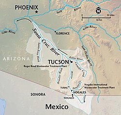
The Santa Cruz River (Spanish: Río Santa Cruz "Holy Cross River") is a left tributary of the Gila River in Southern Arizona and northern Sonora, Mexico. It is approximately 184 miles (296 km) long.[3]
- ^ "Santa Cruz River". Geographic Names Information System. United States Geological Survey, United States Department of the Interior. 1980-02-08. Retrieved 2020-10-05.
- ^ Brown, David E.; Makings, Elizabeth; et al. (April 2017). "Biotic Resources of the Lower Santa Cruz River Flats, Pinal County, Arizona" (PDF). Desert Plants. 32 (2). Archived (PDF) from the original on October 9, 2020. Retrieved October 5, 2020.
- ^ "The National Map". U.S. Geological Survey. Archived from the original on August 23, 2017. Retrieved March 8, 2011.