Back Santa Marta Afrikaans سانتا مارتا (كولومبيا) Arabic Santa Marta (Colombia) AST Santa Marta AVK Santa Marta (Kuluwya) Aymara Santa-Marta Azerbaijani Санта-Марта Byelorussian Санта Марта Bulgarian সানতা মারতা Bengali/Bangla Santa Marta (Colòmbia) Catalan
You can help expand this article with text translated from the corresponding article in Spanish. (December 2013) Click [show] for important translation instructions.
|
Santa Marta | |
|---|---|
District and city | |
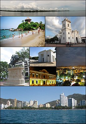
 Top: Panorama of the Cienaga Grande de Santa Marta, 2nd left: Mirador in Cabo San Juan del Guia, Tayrona Natural Park, 2nd right: Santa Marta Cathedral, 3rd left: Statue of Simon Bolívar in Quinta of Saint Pedro Alejandrino, 3rd upper middle: Colombian National Pantheon in Barrio Mamatoco, 3rd lower middle: Santa Marta City Hall, 3rd right: Tribute to the Tayrona Ethnicity Square, Bottom: Panorama of Acuático El Rodadero Park | |
| Nickname: America's Pearl (La Perla de America) | |
 Location in the Department of Magdalena. Municipality (red) City (dark grey) | |
| Coordinates: 11°14′31″N 74°12′19″W / 11.24194°N 74.20528°W | |
| Country | |
| Region | Caribbean Region |
| Department | Magdalena |
| Foundation | July 29, 1525 |
| Founded by | Rodrigo de Bastidas |
| Named for | Martha |
| Government | |
| • Mayor | Virna Lizi Johnson Salcedo (2020–2023) (Fuerza Ciudadana) |
| Area | |
| • District and city | 2,393.65 km2 (924.07 sq mi) |
| • Urban | 55.10 km2 (21.27 sq mi) |
| Elevation | 15 m (49 ft) |
| Population (2018 Census[1]) | |
| • District and city | 499,192 |
| • Density | 210/km2 (540/sq mi) |
| • Urban | 455,299 |
| • Urban density | 8,300/km2 (21,000/sq mi) |
| DANE | |
| Demonym | Samario |
| Time zone | UTC-05:00 (Colombia Time) |
| Postal codes | 470001–470017[2] |
| Area code | 57 + 5 |
| Website | Official website (in Spanish) |
Santa Marta (Spanish pronunciation: [ˌsanta ˈmaɾta]), officially the Distrito Turístico, Cultural e Histórico de Santa Marta (English: Historic, Cultural & Tourist District of Santa Marta), is a port city on the coast of the Caribbean Sea in northern Colombia. It is the capital of Magdalena Department and the fourth-largest urban city of the Caribbean Region of Colombia, after Barranquilla, Cartagena, and Soledad. Founded on July 29, 1525, by the Spanish conqueror Rodrigo de Bastidas, it was one of the first Spanish settlements in Colombia, its oldest surviving city, and second oldest in South America.[3] This city is situated on a bay by the same name and as such, it is a prime tourist destination in the Caribbean region.[4]
- ^ "2018 census" (PDF). Departamento Administrativo Nacional de Estadística (DANE), Colombia (in Spanish). Retrieved 28 May 2022.
- ^ "Santa Marta Postal Codes". Retrieved 2017-08-31.
- ^ "Santa Marta historia y tradición" (in Spanish). Ministerio de Educación Nacional.
- ^ "Colombia" (in Spanish). Decameron. Archived from the original on 26 February 2009. Retrieved 28 May 2009.


