Back نهر سانتي Arabic نهر سانتى ARZ Санці (рака) Byelorussian Santee River CEB Санти (юханшыв) CV Santee River Danish Santee River German Río Santee Spanish Santee (fleuve) French Santee (fiume) Italian
| Santee River | |
|---|---|
 I-95 over Lake Marion | |
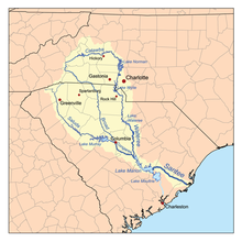
 The Santee River Watershed | |
| Location | |
| Country | United States |
| States | South Carolina |
| Cities | Santee, SC, Cross, SC, Bonneau, SC, Moncks Corner, SC |
| Physical characteristics | |
| Source | Confluence of Congaree River and Wateree Rivers |
| • location | Near Fort Motte, SC |
| • coordinates | 33°44′31.78″N 80°37′02.42″W / 33.7421611°N 80.6173389°W |
| • elevation | 75 ft (23 m) |
| Mouth | Atlantic Ocean |
• location | Charleston County, SC, Georgetown County, SC |
• coordinates | 33°07′48.96″N 79°15′31.73″W / 33.1302667°N 79.2588139°W |
• elevation | 0 ft (0 m) |
| Length | 143 mi (230 km)}[1] |
The Santee River is a river in South Carolina in the United States, and is 143 miles (230 km) long. The Santee and its tributaries provide the principal drainage for the coastal areas of southeastern South Carolina and navigation for the central coastal plain of South Carolina, emptying into the Atlantic Ocean about halfway between Myrtle Beach and Charleston near the community of McClellanville. The farthest headwaters are 440 miles (708 km) away on the Catawba River in North Carolina. Besides the Catawba, other principal rivers of the Santee watershed include the Congaree, Broad, Linville, Saluda and the Wateree. The watershed drains a large portion of the Piedmont regions of South and North Carolina. The Santee River is the second largest river on the eastern coast of the United States, second only to the Susquehanna River in drainage area and flow.[2] Much of the upper river is impounded by the expansive, horn-shaped Lake Marion reservoir, formed by the 8-mile (13 km)-long Santee Dam. The dam was built during the Great Depression of the 1930s as a Works Progress Administration (WPA) project to provide a major source of hydroelectric power for the state of South Carolina.
- ^ "The Santee River". The Sumter Item. Retrieved 14 May 2020.
- ^ "National Water Quality Assessment Program (NAWQA): Santee River Basin Study". U. S. Geological Survey. Retrieved 29 Jan 2022.