Back ساران (الهند) Arabic ساران ARZ सारण जिला AWA सारन जिला Bihari সারন জেলা Bengali/Bangla Districte de Saran Catalan Sāran CEB Saran (Distrikt) German Distrito de Saran Spanish Saran barrutia Basque
Saran district | |
|---|---|
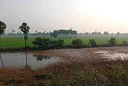
 Agricultural field in Saran district | |
 Location of Saran district in Bihar | |
| Coordinates (Chhapra): 25°55′N 84°45′E / 25.917°N 84.750°E | |
| Country | India |
| State | Bihar |
| Division | Saran |
| Headquarters | Chhapra |
| Tehsils | 20 |
| Government | |
| • Lok Sabha constituencies | 1. Saran, 2. Maharajganj (shared with Siwan district) |
| • Vidhan Sabha constituencies | Ekma, Manjhi, Baniapur, Taraiya, Marhaura, Chapra, Garkha, Amnour, Parsa, Sonpur |
| Area | |
• Total | 2,641 km2 (1,020 sq mi) |
| Population (2011) | |
• Total | 3,951,862 |
| • Density | 1,500/km2 (3,900/sq mi) |
| Demographics | |
| • Literacy | 72.57 per cent |
| • Sex ratio | 949 |
| Time zone | UTC+05:30 (IST) |
| PIN Code | |
| Major highways | NH 28B, NH 85, NH 101, NH 102, NH 19 |
| Website | saran |
Saran district is one of the 38 districts of Indian state of Bihar.[1] The district, part of Saran Division, is also known as Chhapra district after the headquarters of the district, Chhapra.
It is considered as one of the richest zamindaris of Bihar after Raj Darbhanga, Hathwa Raj, Bettiah Raj and Raj Najarganj, Saran Raj.