Back مدينه ساتارا ARZ সাতারা Bengali/Bangla সাতারা BPY Satara Catalan Sātāra (lungsod) CEB Sátárá Czech Satara (Stadt) German Satara Esperanto Satara (Maharashtra) Spanish Satara Finnish
This article needs additional citations for verification. (March 2014) |
Satara | |
|---|---|
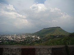
 View from Ajinkyatara Fort of the city of Satara (Maharashtra) | |
 Satara in Maharashtra | |
| Coordinates: 17°41′17″N 74°00′22″E / 17.688°N 74.006°E | |
| Country | |
| State | |
| District | Satara |
| Established | 16th century |
| Founded by | Shahu I |
| Named for | 'Saat Tara' or Saat Tare meaning Seven Stars denoting the seven hill forts in the adjoining areas of the city |
| Government | |
| • Type | Municipal Council |
| • Body | Satara Municipal Council |
| Area | |
• Total | 22.42 km2 (8.66 sq mi) |
| Elevation | 742 m (2,434 ft) |
| Population (2011) | |
• Total | 179,147 (2,011)[1] |
| Demonym | Satarkar |
| Language | |
| • Official | Marathi |
| Time zone | UTC+5:30 (IST) |
| PIN | 415001, 415002, 415003, 415004, 415005, 415006 |
| Telephone code | 02162 |
| Vehicle registration | MH-11 |
| Website | sataranp |
Satara () (ISO: Sātārā) is a city located in the Satara District of Maharashtra state of India, near the confluence of the river Krishna and its tributary, the Venna.[2] The city was established in the 16th century and was the seat of the Chhatrapati of the Maratha Kingdom, Shahu I.
It is the headquarters of Satara Tehsil, as well as the Satara District. The city gets its name from the seven forts (Sat-Tara) which are around the city. The city is known as a Soldier's city as well as Pensioner's city. The city had a population of 179,147 in 2011.[3]
- ^ "सातारा हद्दवाढ भागात नवे 8 प्रभाग : प्रारुप रचना जाहीर". 11 March 2022.
- ^ Chisholm, Hugh, ed. (1911). . Encyclopædia Britannica. Vol. 24 (11th ed.). Cambridge University Press. p. 227.
- ^ "सातारा हद्दवाढ भागात नवे 8 प्रभाग : प्रारुप रचना जाहीर". 11 March 2022.