Back منطقة ساتارا Arabic ساتارا ARZ सतारा जिला Bihari সাতারা জেলা Bengali/Bangla Districte de Satara Catalan Sātāra (subdistrito) CEB Satara (Distrikt) German Distrito de Satara Spanish Satara barrutia Basque بخش ستارا Persian
This article may require cleanup to meet Wikipedia's quality standards. The specific problem is: MOS:STYLE and Office section specifically. (June 2024) |
Satara district
Sātārā Jilhā | |
|---|---|
Clockwise from top-left: Pratapgad Fort, View of Satara from Ajinkyatara Fort, Flowers at Kas Plateau, Bhairavnath Temple in Kikali | |
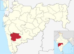
 Location in Maharashtra | |
| Coordinates: 17°42′N 74°00′E / 17.70°N 74.00°E | |
| Country | |
| State | |
| Division | Pune |
| Headquarters | Satara |
| Government | |
| • Body | Satara Zilla Parishad |
| • Guardian Minister | Shambhuraj Desai (Cabinet Minister MH) |
| • President Z. P. Satara | NA |
| • District Collector | Jitendra Dudi (IAS)[1] |
| • CEO Z. P. Satara | Dnyaneshwar Khilari (IAS)[2] |
| • MPs | Udayanraje Bhosale (Satara) Dhairyasheel Patil (Madha) |
| Area | |
• Total | 10,480 km2 (4,050 sq mi) |
| Population (2011) | |
• Total | 3,003,741 |
| • Density | 209/km2 (540/sq mi) |
| Languages | |
| • Official | Marathi |
| Time zone | UTC+5:30 (IST) |
| Tehsils | 1. Satara, 2. Karad, 3. Wai, 4. Mahabaleshwar, 5. Phaltan, 6. Maan, 7. Khatav, 8. Koregaon, 9. Patan, 10. Jaoli, 11. Khandala |
| LokSabha | 1. Satara, 2. Madha (shared with Solapur district) |
| Major Highways | NH-48, NH-160, NH-166E, NH-266, NH-548C, NH-548E, NH-965, NH-965D |
| Website | www |

Satara district (ISO: Sātārā Jilhā; Marathi pronunciation: [saːt̪aɾaː]) is a district of Maharashtra state in western India with an area of 10,480 km2 (4,050 sq mi) and a population of 3,003,741 of which 14.17% were urban (as of 2011[update]).[3][4] Satara is the capital of the district and other major towns include Medha, Wai, Karad, Malkapur, Koregaon, Rahimatpur, Dahiwadi, Koynanagar, Phaltan, Lonand, Mahabaleshwar, Panchgani, Vaduj and Mhaswad. This district comes under Pune Administrative Division along with Pune, Sangli, Solapur and Kolhapur. The district of Pune bounds it to the north, Raigad bounds it to the north-west, Solapur the east, Sangli to the south, and Ratnagiri to the west.[5]
The Sahyadri range, or main range of the Western Ghats, runs north and south along the western edge of the district, separating it from Ratnagiri District. The Mahadeo range starts about 10 m.[clarification needed] north of Mahabaleshwar and stretches east and south-east across the whole of the district. The Mahadeo hills are bold, presenting bare scarps of black rock like fortresses. The Satara district is part of two main watersheds. The Bhima River watershed, which is a tributary of the Krishna, includes the north and northeast of the district, north of the Mahadeo hills. The rest of the district is drained by the upper Krishna and its tributaries. The hill forests have a large store of timber and firewood. The whole of Satara district falls within the Deccan Traps area; the hills consist of trap intersected by strata of basalt and topped with laterite, while, of the different soils on the plains, the commonest is the black loamy clay containing carbonate of lime. This soil, when well watered, is capable of yielding heavy crops. Satara contains some important irrigation works, including the Krishna canal. In some of the western parts of the district the average annual rainfall exceeds 500 cm (200 in); but on the eastern side water is scanty, the rainfall varying from 100 cm (39 in) in Satara town to less than 30 cm (12 in) in some places farther east. The district is traversed from north to south by a railway line, which passes 15 km (9.3 mi) east of Satara town.[6]
The Mandher Devi temple in Mandhradevi, near Wai, is the Kalubai temple. Located on a hill 1,417 m (4,649 ft) above sea level, the temple, some 20 km (12 mi) from Wai, overlooks the picturesque Purandhar Fort. Devotees attribute miraculous properties to a grove around the shrine. Lore has it that the temple is more than 400 years old and was built during Shivaji's rule. However, no definite date on the temple's construction is available. It was the scene of a tragic stampede on 25 January 2005.
- ^ "District Collector Satara". NIC, Govt. of India. Retrieved 11 March 2023.
- ^ "ZP CEO Satara". ZP Satara. Retrieved 11 March 2023.
- ^ "Indian Districts by Population, Sex Ratio, Literacy 2011 Census". Census2011.co.in. 2010-04-01. Retrieved 2015-08-07.
- ^ [1] Archived July 12, 2006, at the Wayback Machine
- ^ Map of districts in Maharashtra
- ^ One or more of the preceding sentences incorporates text from a publication now in the public domain: Chisholm, Hugh, ed. (1911). "Satara". Encyclopædia Britannica. Vol. 24 (11th ed.). Cambridge University Press. p. 227.


