Back مقاطعة شينيكتادي (نيويورك) Arabic Schenectady County, New York BAR Скънектади (окръг, Ню Йорк) Bulgarian স্চেনেকটেডি কাউন্টি, নিউ ইয়র্ক BPY Schenectady Gông (New York) CDO Скенектади (гуо, Нью-Йорк) CE Schenectady County CEB Schenectady County Czech Schenectady County, Efrog Newydd Welsh Schenectady County German
This article needs additional citations for verification. (January 2009) |
Schenectady County | |
|---|---|
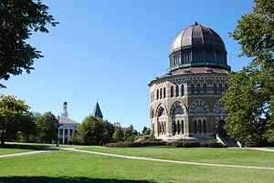
 The Nott Memorial | |
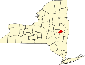
 Location within the U.S. state of New York | |
 New York's location within the U.S. | |
| Coordinates: 42°49′N 74°04′W / 42.81°N 74.07°W | |
| Country | |
| State | |
| Founded | 1809 |
| Named for | Mohawk skahn-éht-ati, "beyond the pines" |
| Seat | Schenectady |
| Largest city | Schenectady |
| Area | |
| • Total | 209 sq mi (540 km2) |
| • Land | 205 sq mi (530 km2) |
| • Water | 4.9 sq mi (13 km2) 2.3% |
| Population (2020) | |
| • Total | 158,061[1] |
| • Density | 772.3/sq mi (298.2/km2) |
| Time zone | UTC−5 (Eastern) |
| • Summer (DST) | UTC−4 (EDT) |
| Congressional district | 20th |
| Website | www |
Schenectady County (/skəˈnɛktədi/) is a county in the U.S. state of New York. As of the 2020 census, the population was 158,061.[2] The county seat is Schenectady.[3] The name is from a Mohawk language word meaning "on the other side of the pine lands," a term that originally applied to Albany. The county is part of the Capital District region of the state.
Schenectady County is part of the Albany-Schenectady-Troy, NY Metropolitan Statistical Area, and is west of the confluence of the Mohawk with the Hudson River. It includes territory on the north and the south sides of the Mohawk River.
- ^ "US Census 2020 Population Dataset Tables for New York". United States Census Bureau. Retrieved January 2, 2022.
- ^ "U.S. Census Bureau QuickFacts: Schenectady County, New York". United States Census Bureau. Retrieved January 2, 2022.
- ^ "Find a County". National Association of Counties. Retrieved June 7, 2011.

