Back سی فورث، نیو ساوت ولز Persian Seaforth (Nowa Południowa Walia) Polish Seaforth (Nova Gales do Sul) Portuguese Seaforth, New South Wales Romanian
| Seaforth Sydney, New South Wales | |||||||||||||||
|---|---|---|---|---|---|---|---|---|---|---|---|---|---|---|---|
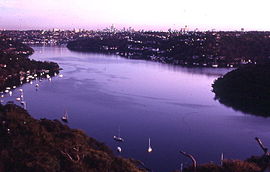
 View of Middle Harbour from Seaforth | |||||||||||||||
 | |||||||||||||||
| Population | 7,384 (SAL 2021)[1] | ||||||||||||||
| Established | 1906 | ||||||||||||||
| Postcode(s) | 2092 | ||||||||||||||
| Elevation | 70 m (230 ft) | ||||||||||||||
| Area | 3.1 km2 (1.2 sq mi) | ||||||||||||||
| Location | 12 km (7 mi) north-east of Sydney CBD | ||||||||||||||
| LGA(s) | Northern Beaches Council | ||||||||||||||
| State electorate(s) | Manly | ||||||||||||||
| Federal division(s) | Warringah | ||||||||||||||
| |||||||||||||||


Seaforth is a suburb of Northern Sydney, in the state of New South Wales, Australia. Seaforth is located 12 kilometres north-east of the Sydney central business district in the local government area of Northern Beaches Council and is part of the Northern Beaches region.
Seaforth overlooks Middle Harbour and is linked south to Mosman by the Spit Bridge. To the west, Seaforth overlooks Sugarloaf Bay across to the suburbs of Northbridge, Castlecrag and Castle Cove. The Garigal National Park sits on the northern border.[2]
- ^ Australian Bureau of Statistics (28 June 2022). "Seaforth (NSW) (suburb and locality)". Australian Census 2021 QuickStats. Retrieved 28 June 2022.
- ^ The Book of Sydney Suburbs, Compiled by Frances Pollon, Angus & Robertson Publishers, 1990, Published in Australia ISBN 0-207-14495-8