Back شط العرب Arabic شط العرب ARZ Şəttül-Ərəb Azerbaijani شط العرب AZB Шәтт әл-Ғәрәп Bashkir Salog Shatt-al-Arab BCL Арвандруд BE-X-OLD Шат ал-Араб Bulgarian शत अल अरब Bihari শাতিল আরব Bengali/Bangla
| Shatt al-Arab | |
|---|---|
 | |
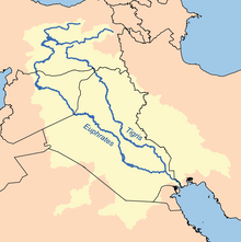
 Drainage basin and two major tributaries | |
| Location | |
| Country | Iraq, Iran, Kuwait[1][2] |
| Physical characteristics | |
| Source | Euphrates |
| • elevation | 4 m (13 ft) |
| 2nd source | Tigris |
| • elevation | 4 m (13 ft) |
| Mouth | |
• location | Persian Gulf |
• coordinates | 30°24′15.59″N 48°09′3.60″E / 30.4043306°N 48.1510000°E |
• elevation | 0 m (0 ft) |
| Length | 204 km (127 mi)[3] |
| Basin size | 938,173 km2 (362,231 sq mi)[3] to 884,000 km2 (341,000 sq mi) |
| Width | |
| • minimum | 250 m (820 ft)[3] |
| • maximum | 1,500 m (4,900 ft)[3] |
| Discharge | |
| • location | Shatt al-Arab Delta, Persian Gulf |
| • average | (Period: 1971–2000)3,535 m3/s (124,800 cu ft/s)[4] (Period: 1977–2018)105.7 km3/a (3,350 m3/s)[3] |
| Discharge | |
| • location | Abadan, Iran |
| • average | (Period: 1971–2000)3,531.6 m3/s (124,720 cu ft/s)[4] |
| Discharge | |
| • location | Basra, Iraq |
| • average | (Period: 1971–2000)2,782.8 m3/s (98,270 cu ft/s)[4] |
| Discharge | |
| • location | Al-Qurnah, Iraq (confluence of Tigris and Euphrates rivers) |
| • average | (Period: 1971–2000)2,531.8 m3/s (89,410 cu ft/s)[4] |
| Basin features | |
| Tributaries | |
| • left | Tigris, Alswaib canal, Karun |
| • right | Euphrates |
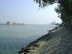
The Shatt al-Arab (Arabic: شط العرب, lit. 'River of the Arabs'; Persian: اروندرود, romanized: Arvand Rud, lit. 'Swift River'[5]) is a river about 200 kilometres (120 mi) in length that is formed at the confluence of the Euphrates and Tigris rivers in the town of al-Qurnah in the Basra Governorate of southern Iraq. The southern end of the river constitutes the Iran–Iraq border down to its mouth, where it discharges into the Persian Gulf. The Shatt al-Arab varies in width from about 232 metres (761 ft) at Basra to 800 metres (2,600 ft) at its mouth. It is thought that the waterway formed relatively recently in geological time, with the Tigris and Euphrates originally emptying into the Persian Gulf via a channel further to the west. Kuwait's Bubiyan Island is part of the Shatt al-Arab delta.[1]
The Karun, a tributary which joins the waterway from the Iranian side, deposits large amounts of silt into the river; this necessitates continuous dredging to keep it navigable.[6]
The area used to hold the largest date palm forest in the world. In the mid-1970s, the region included 17–18 million date palms: an estimated one-fifth of the world's 90 million palm trees. However, by 2002, more than 14 million of the palms had been wiped out by the combined factors of war, salt and pests; this count includes around 9 million palms in Iraq and 5 million in Iran. Many of the remaining 3–4 million trees are in poor health.[7]
- ^ a b Reinink-Smith, Linda; Carter, Robert (2022). "Late Holocene development of Bubiyan Island, Kuwait". Quaternary Research. 109: 16–38. Bibcode:2022QuRes.109...16R. doi:10.1017/qua.2022.3. S2CID 248250022.
- ^ "Global Climate Change Impacts on Tigris Euphrates Rivers Basins" (PDF). p. 55.
- ^ a b c d e Safaa, Al-Asadi; Abdulzahra, Alhello (2019). "General assessment of Shatt Al-Arab River, Iraq". International Journal of Water. 13: 360-375. doi:10.1504/IJW.2019.106049.
- ^ a b c d "Tigris Euphrates Delta-Coastal".
- ^ "Shatt al Arab". Oxford Public International Law. Retrieved 23 April 2022.
The Shatt al Arab river (or Arvand Rud in Persian) is the confluence of the Euphrates and the Tigris (Tigris and Euphrates Rivers), which starts in the Iraqi town of Al-Qornah and after circa 120 miles flows into the Persian Gulf.
- ^ "Iraq – Major Geographical Features". country-data.com. Retrieved 28 November 2015.
- ^ "UNEP/GRID-Sioux Falls". unep.net. Retrieved 28 November 2015.