Back Tel Shimron CEB Tel Šimron Czech תל שמרון HE シムロン Japanese Tel Szimron Polish Sinrom Portuguese Tel Shimron Swedish
This article may require copy editing for grammar, style, cohesion, tone, or spelling. (April 2024) |
תל שמרון | |
 | |
| Alternative name | Simonias, Tell Samunia |
|---|---|
| Location | Jezreel Valley, Israel |
| Region | Lower Galilee |
| Coordinates | 32°42′13″N 35°12′50″E / 32.70361°N 35.21389°E |
| Type | Archaeological site |
| Area | 19.5 hectares (Middle Bronze Age) |
| History | |
| Periods | Neolithic, Chalcolithic, Bronze Age, Iron Age, Persian, Hellenistic, Roman, Byzantine, Early Islamic, Crusader, Mamluk |
| Site notes | |
| Excavation dates | 2004–2010, 2016–present |
| Archaeologists | Victor Guérin, Yuval Portugali, Avner Raban, Nurit Feig, Yardenna Alexandre, Daniel M. Master, Mario A. S. Martin |
| Condition | Ruined |
| Public access | Yes |
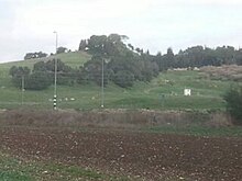
Tel Shimron (Hebrew: תל שמרון) is an archaeological site and nature reserve in the Jezreel Valley.
Shimron was the name of a major city in the north of Israel throughout antiquity. It is mentioned in the Hebrew Bible by this name, and in other period sources as Shim'on. It became an administrative center under Assyrian, Babylonian and Persian rule. During the early Roman period, the city was expanded and fortified by Herod, who renamed it Sebastiya in honor of emperor Augustus.[1] In Late Antiquity, it was known by the name Simonias (Hebrew: סימונייה), as mentioned by Flavius Josephus.[2] The Arabic name of the site is Tell Samunia, also written Samunieh.[3][4]
Tel Shimron is located northeast of modern moshav Nahalal on the western edge of the Nazareth range,[5] on the border between the Lower Galilee and the Jezreel Valley. Its location at the intersection of the Lower Galilee ranges and the Jezreel Valley, as well as its proximity to the Acre (Akko) Plain, made it an important part of trade routes through the area.[6]
In recent years, the site is being excavated by Tel Shimron Excavations (2016-present; for homepage see here) in cooperation with the Jezreel Valley Regional Project.[7]
- ^ Rainey, Anson F. (1998). "Review of Tabula imperii romani: Iudaea-Palaestina, Eretz Israel in the Hellenistic, Roman, and Byzantine Periods". Journal of the American Oriental Society. 118 (1): 71–73. doi:10.2307/606301. ISSN 0003-0279. JSTOR 606301.
- ^ "Flavius Josephus, Josephi vita, Whiston section 24". www.perseus.tufts.edu. Retrieved 2022-02-01.
- ^ "Bible Encyclopedia: Shimron". bibleencyclopedia.com. Retrieved 2022-02-01.
- ^ Mazar, Benjamin, ed. (1960-08-19). "From the President of the Hebrew University of Jerusalem". Textus. 1 (1): v. doi:10.1163/2589255x-00101002. ISSN 0082-3767.
- ^ "Volume 133 Year 2021 Tel Shimron – 2017, 2019". www.hadashot-esi.org.il. Retrieved 2022-02-01.
- ^ "Geographic Setting". Tel Shimron Excavations - Volunteer Archaeology Digs. Retrieved 2022-02-01.
- ^ "Academic Affiliates". Tel Shimron Excavations - Volunteer Archaeology Digs. Retrieved 2023-05-23.