Back শিন্দান্দ জেলা Bengali/Bangla Shīnḏanḏ (distrito) CEB Shindand (Distrikt) German ولسوالی شیندند Persian Distretto di Shindand Italian Daerah Shindand Malay ضلع شیندند PNB شين ډنډ ولسوالۍ Pashto/Pushto Shindand (distrikt) Swedish Şindend ilçesi Turkish
Shindand
شينډنډ | |
|---|---|
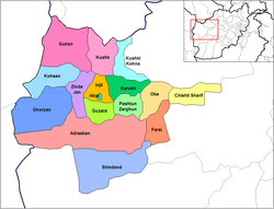
 Shindand District (in south) on Herat province map | |
| Coordinates: 33°18′13″N 62°08′24″E / 33.3036°N 62.1400°E | |
| Country | |
| Province | Herat Province |
| Capital | Shindand |
| Population (2021)[1] | |
| • Total | 49,024 |
| Time zone | UTC+4:30 |
Shinḍanḍ District[2][3][4] (Pashto: شينډنډ) is located in the southern part of Herat Province in Afghanistan, bordering Adraskan District to the north, Ghor Province to the east and Farah Province to the south and west. It is one of the 16 districts of Herat Province. The name Shindand is Pashto and relates to lush green farming area. In Persian language it translates to Sabzwār (سبزوار).
The population of Shindand District is around 49,024.[1] The district center is the town of Shindand, which has an active market area.[5] Shindand Air Base is located near the town. The Kandahar–Herat Highway passes through the district. The Zerkoh Valley is in the district.
- ^ a b Cite error: The named reference
populationwas invoked but never defined (see the help page). - ^ "Disputes among Shindand residents almost resolved". Pajhwok Afghan News. 29 December 2022. Retrieved 2022-12-29.
- ^ "Afghan Taliban Say They'll Suspend Fighting in Their Areas if Coronavirus Hits". Voice of America. April 2, 2020. Retrieved 2022-12-29.
- ^ "In an Afghan District Verging on Collapse: 'There Are Too Many Men With Guns'". The New York Times Magazine. December 12, 2018. Retrieved 2022-12-29.
- ^ Trip to Shindand district, first part on YouTube
