Back Sinai Afrikaans Sinai-Halbinsel ALS የሲና ልሳነ ምድር Amharic Peninsula d'o Sinai AN شبه جزيرة سيناء Arabic ܣܝܢܝ (ܓܙܪܬܐ ܝܒܫܢܝܬܐ) ARC سينا ARZ Península del Sinaí AST Синаялъул бащдаб чӀинкӀиллъи AV Sinay yarımadası Azerbaijani
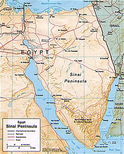
 Shaded relief map of the Sinai Peninsula, 1992, produced by the U.S. Central Intelligence Agency. | |
 | |
| Geography | |
|---|---|
| Coordinates | 29°30′N 33°48′E / 29.500°N 33.800°E |
| Area | 60,000 km2 (23,000 sq mi) |
| Administration | |
| Largest settlement | Arish |
| Demographics | |
| Population | 600,000[1] |
| Pop. density | 10/km2 (30/sq mi) |
The Sinai Peninsula, or simply Sinai (/ˈsaɪnaɪ/ SY-ny; Arabic: سِينَاء; Egyptian Arabic: سينا; Coptic: Ⲥⲓⲛⲁ), is a peninsula in Egypt, and the only part of the country located in Asia. It is between the Mediterranean Sea to the north and the Red Sea to the south, and is a land bridge between Asia and Africa. Sinai has a land area of about 60,000 km2 (23,000 sq mi) (6 percent of Egypt's total area) and a population of approximately 600,000 people.[1] Administratively, the vast majority of the area of the Sinai Peninsula is divided into two governorates: the South Sinai Governorate and the North Sinai Governorate. Three other governorates span the Suez Canal, crossing into African Egypt: Suez Governorate on the southern end of the Suez Canal, Ismailia Governorate in the center, and Port Said Governorate in the north.
In the classical era, the region was known as Arabia Petraea. The peninsula acquired the name Sinai in modern times due to the assumption that a mountain near Saint Catherine's Monastery is the Biblical Mount Sinai.[2] Mount Sinai is one of the most religiously significant places in the Abrahamic faiths.
The Sinai Peninsula has been a part of Egypt from the First Dynasty of ancient Egypt (c. 3100 BC). This comes in stark contrast to the region north of it, the Levant (the present-day territories of Syria, Lebanon, Jordan, Israel and Palestine), which, due largely to its strategic geopolitical location and cultural convergences, has historically been the center of conflict between Egypt and various states of Mesopotamia and Asia Minor. In periods of foreign occupation, the Sinai was, like the rest of Egypt, also occupied and controlled by foreign empires, in more recent history the Ottoman Empire (1517–1867) and the United Kingdom (1882–1956). Israel invaded and occupied Sinai during the Suez Crisis (known in Egypt as the Tripartite Aggression due to the simultaneous coordinated attack by the UK, France and Israel) of 1956, and during the Six-Day War of 1967. On 6 October 1973, Egypt launched the Yom Kippur War, seizing most of the east bank of the Suez Canal and negotiating the rest of Sinai. In 1982, as a result of the Egypt–Israel peace treaty of 1979, Israel withdrew from all of the Sinai Peninsula except the contentious territory of Taba, which was returned after a ruling by a commission of arbitration in 1989.
Today, Sinai has become a tourist destination due to its natural setting, rich coral reefs, and biblical history.
- ^ a b January 2018 population data gives the North and South governorates' population at approximately 560,000 (per "اPop. Estimates by Governorate 1/1/2018". www.capmas.gov.eg. Archived from the original on 2 November 2018.). In 1997 these two governorates accounted for 97% of the peninsula's population.Greenwood, Ned (1997). The Sinai: A Physical Geography. University of Texas Press. pp. 5. ISBN 978-0-292-72799-1.
Over 94 percent of the area and probably 97 percent of the population are found in the large governorates, leaving less than 6 percent of the area and 3 percent of the population attached to As Suways (Suez), Al Ismailiyah (Ismailia),and Bur Said (Port Said) governorates.
- ^ De Vaux, Roland (1978). The Early History of Israel. Darton, Longman & Todd. p. 429. ISBN 978-0-232-51242-7.
The name 'Sinai peninsula' is modern. It is derived from the Christian tradition, according to which Sinai was located in the south of the peninsula. This Christian tradition goes back to the fourth century, to the time when the Spanish pilgrim Egeria (or Etheria) visited Sinai in A.D. 383. From this time onwards, Christians grouped all the Old Testament memories round the Jebel Musa.