Back Sint Eustatius Afrikaans Sint Eustatius ALS Isla de Sant Eustaquio AN سينت أوستاتيوس Arabic سينت اوستاتيوس ARZ Sint-Estatius Azerbaijani Синт-Эстатиус Bashkir Сінт-Эстатыус Byelorussian Синт Еустациус Bulgarian Sint Eustatius Breton
Sint Eustatius | |
|---|---|
Special municipality of the Netherlands | |
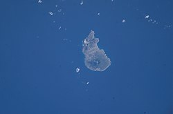
 Satellite image of Sint Eustatius | |
| Motto(s): | |
| Anthem: "Golden Rock" | |
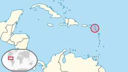
 Location of Sint Eustatius (circled in red) in the Caribbean | |
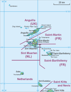
 Map showing the location of St. Eustatius relative to Saba and St. Martin | |
| Coordinates: 17°29′N 62°59′W / 17.483°N 62.983°W | |
| Country | |
| Overseas region | Caribbean Netherlands |
| Incorporated into the Netherlands | 10 October 2010 (dissolution of the Netherlands Antilles) |
| Capital (and largest city) | Oranjestad |
| Government | |
| • Lt. Governor | Alida Francis (Government commissioner)[1] |
| Area | |
• Total | 21 km2 (8 sq mi) |
| Population (1 January 2024)[3] | |
• Total | 3,204 |
| • Density | 154/km2 (405/sq mi) |
| Demonyms |
|
| Languages | |
| • Official | English[4] • Dutch |
| Time zone | UTC−4 (AST) |
| Calling code | +599-3 |
| ISO 3166 code | BQ-SE, NL-BQ3 |
| Currency | United States dollar ($) (USD) |
| Internet TLD | |
Sint Eustatius (/juːˈsteɪʃəs/ yoo-STAY-shəs, Dutch: [sɪnt øːˈstaː(t)sijʏs] ),[7] known locally as Statia (/ˈsteɪʃə/ STAY-shə),[8] is an island in the Caribbean. It is a special municipality (officially "public body") of the Netherlands.[9]
The island is in the northern Leeward Islands, southeast of the Virgin Islands. Sint Eustatius is immediately to the northwest of Saint Kitts and southeast of Saba. The regional capital is Oranjestad. The island has an area of 21 square kilometres (8.1 sq mi).[2] Travelers to the island by air arrive through F. D. Roosevelt Airport.
Formerly part of the Netherlands Antilles, Sint Eustatius became a public body of the Netherlands in 2010.[10] It is part of the Dutch Caribbean, which consists of Aruba, Bonaire, Curaçao, Saba, Sint Eustatius, and Sint Maarten. Together with Bonaire and Saba, it forms the BES Islands, also referred to as the Caribbean Netherlands.[11]
- ^ "Benoeming regeringscommissaris en plaatsvervanger Sint Eustatius". Rijksoverheid (in Dutch). 18 June 2021. Archived from the original on 28 May 2023. Retrieved 19 December 2021.
- ^ a b "Waaruit bestaat het Koninkrijk der Nederlanden?". Rijksoverheid (in Dutch). 19 May 2015. Retrieved 5 April 2022.
- ^ "Population of the Caribbean Netherlands up by nearly a thousand in 2023". 30 May 2024.
- ^ English can be used in relations with the government, see, Invoeringswet openbare lichamen Bonaire, Sint Eustatius en Saba (in Dutch) – via Overheid.nl.
- ^ "BQ – Bonaire, Sint Eustatius and Saba". ISO. Archived from the original on 17 June 2016. Retrieved 29 August 2014.
- ^ "Delegation Record for .BQ". IANA. 20 December 2010. Archived from the original on 29 May 2012. Retrieved 30 December 2010.
- ^ Mangold, Max. Duden – Das Aussprachewörterbuch. In: Der Duden in zwölf Bänden, Band 6. 7. Auflage. Berlin: Dudenverlag; Mannheim : Institut für Deutsche Sprache, 2015, Seite 786.
- ^ Tuchman, Barbara W. (1988). The First Salute: A View of the American Revolution. New York: Ballantine Books.
- ^ Wet openbare lichamen Bonaire, Sint Eustatius en Saba [Law on the public bodies of Bonaire, Sint Eustatius and Saba] (in Dutch) – via Overheid.nl.
- ^ "Antillen opgeheven op 10-10-2010". NOS Nieuws (in Dutch). 18 November 2009. Archived from the original on 24 December 2009. Retrieved 10 October 2010.
- ^ Zaken, Ministerie van Algemene (19 May 2015). "Waaruit bestaat het Koninkrijk der Nederlanden? – Rijksoverheid.nl". www.rijksoverheid.nl (in Dutch). Retrieved 28 March 2023.[permanent dead link]
Cite error: There are <ref group=lower-alpha> tags or {{efn}} templates on this page, but the references will not show without a {{reflist|group=lower-alpha}} template or {{notelist}} template (see the help page).

