Back Skidegate CEB Skidegate German Skidegate Finnish Skidegate French Skidegate Croatian Skidegate NB Skidegate Portuguese Skidegate Swedish
Skidegate Hlg̱aagilda | |
|---|---|
Indigenous reserve | |
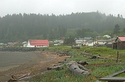
 View of the Kay Llnagaay beach in Skidegate. | |
Location of Skidegate in Haida Gwaii | |
| Coordinates: 53°16′02″N 131°59′26″W / 53.26722°N 131.99056°W | |
| Country | |
| Province | |
| Region | Haida Gwaii |
| Regional district | Skeena-Queen Charlotte |
| Founded | 1850 |
| Government | |
| • Chief Councillor | Willard Wilson |
| Area | |
• Total | 5.65 km2 (2.18 sq mi) |
| Elevation | 28 m (92 ft) |
| Population (2016)[1] | |
• Total | 837 |
| • Density | 138.3/km2 (358/sq mi) |
| Time zone | UTC−8 (PST) |
| • Summer (DST) | UTC−7 (PDT) |
| Highways | |
| Waterways | Hecate Strait |
Skidegate /ˈskɪdɪɡɪt/ (Haida: Hlg̱aagilda)[2] is a Haida community in Haida Gwaii in British Columbia, Canada. It is on the southeast coast of Graham Island,[3] the largest island in the archipelago, and is approximately 50 kilometres (31 mi) west of mainland British Columbia across Hecate Strait.
Skidegate, which is on Skidegate Indian Reserve No. 1 and was formerly home to the Skidegate Mission[4][5] is also the northern terminal for the BC Ferries service between Graham Island and Alliford Bay on Moresby Island.
- ^ "Census Profile, 2016 Census". February 5, 2016.
- ^ "FirstVoices: Hlg̱aagilda X̱aayda Kil: words". Retrieved July 8, 2012.
- ^ "BC Geographical Names". apps.gov.bc.ca. Archived from the original on February 26, 2014. Retrieved February 26, 2014.
- ^ "BC Geographical Names". apps.gov.bc.ca. Archived from the original on February 26, 2014. Retrieved February 26, 2014.
- ^ "BC Geographical Names". apps.gov.bc.ca. Archived from the original on February 26, 2014. Retrieved February 26, 2014.
