Back سليفورد Arabic سليفورد ARZ اسلیفورد AZB Sleaford (lungsod) CEB Sleaford Welsh Sleaford German Sleaford Spanish Sleaford Basque اسلیفورد Persian Sleaford French
| Sleaford | |
|---|---|
| Town and civil parish | |
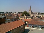
Clockwise from top: Aerial of Sleaford Castle site, Handley Monument, St Deny's Church, view across rooftops of Sleaford and Sessions House (on the right) | |
Location within Lincolnshire | |
| Population | 19,807 (2021 Census)[1] |
| OS grid reference | TF064455 |
| • London | 100 mi (160 km) S |
| District | |
| Shire county | |
| Region | |
| Country | England |
| Sovereign state | United Kingdom |
| Areas of the town | |
| Post town | SLEAFORD |
| Postcode district | NG34 |
| Dialling code | 01529 |
| Police | Lincolnshire |
| Fire | Lincolnshire |
| Ambulance | East Midlands |
| UK Parliament | |
| Website | www.sleaford.gov.uk |
Sleaford is a market town and civil parish in the North Kesteven district of Lincolnshire, England. On the edge of the Fenlands, it is 11 miles (18 kilometres) north-east of Grantham, 16 mi (26 km) west of Boston, and 17 mi (27 km) south of Lincoln. It is the largest settlement in North Kesteven with a population of 19,807 in 2021. Centred on the former parish of New Sleaford, the modern boundaries and urban area include Quarrington to the south-west, Holdingham to the north-west and Old Sleaford to the east. The town is bypassed by the A17 and the A15 roads, which link it to Lincoln, Newark, Peterborough, Grantham, Boston and King's Lynn. Sleaford railway station is on the Nottingham to Skegness (via Grantham) and Peterborough to Lincoln lines.
The first settlement formed in the Iron Age where a prehistoric track crossed the River Slea. It was a tribal centre and home to a mint for the Corieltauvi in the 1st centuries BC and AD. Evidence of Roman and Anglo-Saxon settlement has been found. The medieval records differentiate between Old and New Sleaford, the latter emerging by the 12th century around the present-day market place and St Denys' Church; Sleaford Castle was also built at that time for the Bishops of Lincoln, who owned the manor. Granted the right to hold a market in the mid-12th century, New Sleaford developed into a market town and became locally important in the wool trade, while Old Sleaford (based near the site of the prehistoric settlement) declined.
From the 16th century, the landowning Carre family kept tight control over the town – it grew little in the early modern period. The manor passed from the Carre family to the Hervey family by the marriage of Isabella Carre to John Hervey, 1st Earl of Bristol in 1688. The town's common land and fields were legally enclosed by 1794, giving ownership mostly to the Hervey family. This coincided with canalisation of the Slea, which brought economic growth until it was superseded by the railways in the mid-1850s. These new transport links supported the development of light industries and expanded the town's role in the trade in agricultural goods. Long a centre for local justice and administration in north Kesteven, Sleaford became an urban district in 1894 and was also home to other public bodies including the now-abolished Kesteven County Council (1925–1974). After a period of stagnation, in the late 20th and early 21st centuries the sale of farmland around Sleaford led to the development of large housing estates, causing the population to rapidly expand and the urban area to engulf Quarrington and Holdingham.
Sleaford was a market town until the 20th century, serving a rural hinterland. Seed companies such as Hubbard and Phillips and Sharpes International were established in the late 19th century, though have since closed. The arrival of the railway made the town favourable for malting, but the Bass Maltings closed in the 1950s. Though its traditional market has also declined sharply in the 21st century (and its cattle and corn markets shut in the 20th century), Sleaford's economy has diversified. The town remains an important administrative, service and commercial centre for the surrounding district. It houses supermarkets, shops and a large business park with offices and light manufacturing, and is home to the headquarters of North Kesteven District Council; three secondary schools (two of which are selective); four primary schools; three newspapers; police, fire and ambulance stations; several places of worship; many sports clubs; a leisure centre; and several medical and dental practices and care homes. Regeneration has transformed some earlier industrial areas, including through the construction of the National Centre for Craft & Design (The Hub). The town is one of the largest employment centres in the district; the commonest employers in 2021 were the public sector, retail and, to a much lesser degree, manufacturing.
- ^ "Sleaford". City population. Retrieved 25 October 2022.


