Back সোনমার্গ Bengali/Bangla Sonāmarg CEB Sonamarg German सोनमर्ग Hindi Sonamarg ID سۄنہٕ مرٕگ Kashmiri സോനാമാർഗ് Malayalam सोनमर्ग Marathi ਸੋਨਮਾਰਗ Punjabi सोनमार्गः Sanskrit
Sonamarg
Sonamarag Sonmarg | |
|---|---|
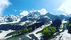
 Northern Sonamarg photographed in 2017 | |
| Coordinates: 34°20′N 75°20′E / 34.33°N 75.33°E | |
| Country | |
| Union territory | Jammu and Kashmir |
| District | Ganderbal |
| Elevation | 2,730 m (8,960 ft) |
| Population | |
| • Total | 392 |
| Languages | |
| • Official | Kashmiri, Urdu, Hindi, Dogri, English[1][2] |
| • Spoken | Pahari, Gujari, Shina, Balti, Phustu |
| Time zone | UTC+5:30 (IST) |
| PIN | 191202 |
| Telephone code | +91-1942417- |
| Vehicle registration | JK16 |
Sonamarg or Sonmarg (Urdu pronunciation: [soːnɑːməɾɡ]), known as Sonamarag[3] (Kashmiri pronunciation: [sɔnɨmarɨɡ]; lit. 'meadow of gold')[4] in Kashmiri, is a hill station located in the Ganderbal District of Jammu and Kashmir, India. It is located about 62 kilometers from Ganderbal Town and 80 kilometres (50 mi) northeast of the capital city, Srinagar.

- ^ "The Jammu and Kashmir Official Languages Act, 2020" (PDF). The Gazette of India. 27 September 2020. Retrieved 27 September 2020.
- ^ "Parliament passes JK Official Languages Bill, 2020". Rising Kashmir. 23 September 2020. Retrieved 23 September 2020.
- ^ Toshakhani, S.K; Koul, Lal; Hajni, Mohiuddin; Pushp, P; Mohiuddin, Akhtar (1968–1980). Kashir Dictionary (in Kashmiri). Vol. 4. Jammu and Kashmir Academy of Art, Culture and Languages. p. 244.
- ^ Mitra, Swati (2013). Jammu & Kashmir: Travel Guide. Eicher Goodearth. p. 46. ISBN 9789380262451.
'Meaning the 'meadow of gold', Sonamarg is covered with yellow crocus flowers in spring'

