Back اقفال سو ARZ Soo Locks CEB Soo Locks Czech Soo Locks German Écluses du Sault French सू नहर Hindi Chiuse di Soo Italian スーセントマリー運河 Japanese Soo Locks Dutch Soo Locks Swedish
St. Marys Falls Canal | |
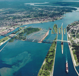
 Aerial view of the Soo Locks. View is looking east, with Canada on the left and the United States on the right | |
| Location | Sault Ste. Marie, Michigan |
|---|---|
| Coordinates | 46°30′12″N 84°21′00″W / 46.50333°N 84.35000°W |
| Built | 1855 |
| Architect | Corps of Engineers |
| NRHP reference No. | 66000394[1] |
| Significant dates | |
| Added to NRHP | November 13, 1966 |
| Designated NHL | November 13, 1966[3] |
| Designated MSHS | February 12, 1959[2] |
The Soo Locks (sometimes spelled Sault Locks but pronounced "soo") are a set of parallel locks, operated and maintained by the United States Army Corps of Engineers, Detroit District, that enable ships to travel between Lake Superior and the lower Great Lakes. They are located on the St. Marys River between Lake Superior and Lake Huron, between the Upper Peninsula of the U.S. state of Michigan and the Canadian province of Ontario. They bypass the rapids of the river, where the water falls 21 ft (6.4 m). The locks pass an average of 10,000 ships per year,[4] despite being closed during the winter from January through March, when ice shuts down shipping on the Great Lakes. The winter closure period is used to inspect and maintain the locks.
The locks share a name (usually shortened and anglicized as Soo) with the two cities named Sault Ste. Marie, in Ontario and in Michigan, located on either side of the St. Marys River. The Sault Ste. Marie International Bridge between the United States and Canada permits vehicular traffic to pass over the locks. A railroad bridge crosses the St. Marys River just upstream of the highway bridge.
The first locks were opened in 1855. Along with the Erie Canal, constructed in 1824 in central New York State, they were among the great infrastructure engineering projects of the antebellum United States. The Soo Locks were designated a National Historic Landmark in 1966.[5]
- ^ "National Register Information System". National Register of Historic Places. National Park Service. January 23, 2007.
- ^ State Historic Preservation Office (2009). "Saint Mary's Falls Canal". Historic Sites Online. Michigan State Housing Development Authority. Archived from the original on May 11, 2012. Retrieved June 26, 2010.
- ^ "St. Marys Falls Canal". National Historic Landmark summary listing. National Park Service. Archived from the original on October 6, 2012. Retrieved June 27, 2008.
- ^ Detroit District. "Facts". United States Army Corps of Engineers. Archived from the original on January 10, 2011. Retrieved October 22, 2008.
- ^ "NHL nomination for St. Marys Falls Canal". National Park Service. Archived from the original on August 28, 2022. Retrieved April 3, 2017.

