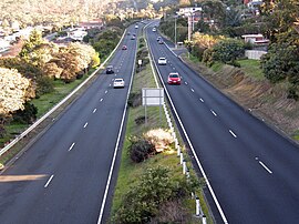
South Arm Highway | |
|---|---|
 | |
| South Arm Highway at Howrah | |
 | |
| Coordinates | |
| General information | |
| Type | Highway |
| Length | 4.2 km (2.6 mi)[1] |
| Opened | 1989[2] |
| Route number(s) | |
| Major junctions | |
| North end | |
| |
| South end | |
| Location(s) | |
| Region | Hobart |
| Highway system | |
| ---- | |
The South Arm Highway (part of the B33 road route) is a highway serving the southern suburbs of Hobart, on the eastern shore of the River Derwent in Tasmania, Australia. The highway is a major trunk road that carries heavy commuter traffic south from the Eastern Outlet to Howrah and Rokeby. As one of the Tasman Highway's principle Feeders and one of the eastern shore's major transport corridors, The South Arm Highway facilitates the movement of traffic between the suburbs and satellite communities to the south with the city centre and ultimately, other major cross city highways. With annual average daily traffic (AADT) of 17,000,[2] the highway is considered a major traffic corridor within Hobart. The designation "South Arm Highway" arises from its journey south (via Rokeby Road) to South Arm.
- ^ Cite error: The named reference
gmapswas invoked but never defined (see the help page). - ^ a b "South Arm Highway, Shoreline Drive to Oceana Drive - Duplication" (PDF). Parliament of Tasmania. 2007. Retrieved 9 February 2014.

