This article needs additional citations for verification. (January 2018) |
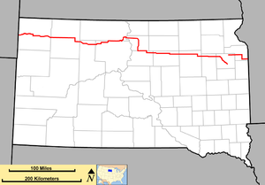
 Map of South Dakota with SD 20 in red | ||||
| Route information | ||||
| Maintained by SDDOT | ||||
| Length | 385.079 mi[1][2][3] (619.725 km) | |||
| Existed | c. 1930[citation needed]–present | |||
| Tourist routes | ||||
| Western segment | ||||
| Length | 346.065 mi[1][2][3] (556.938 km) | |||
| West end | Montana state line near Camp Crook | |||
| Major intersections | ||||
| East end | ||||
| Eastern segment | ||||
| Length | 39.014 mi[3] (62.787 km) | |||
| West end | ||||
| Major intersections | ||||
| East end | ||||
| Location | ||||
| Country | United States | |||
| State | South Dakota | |||
| Counties | ||||
| Highway system | ||||
| ||||
| ||||
South Dakota Highway 20 (SD 20) is a 385.079-mile (619.725 km) state highway in northern South Dakota, United States, that connects the Montana state line, west-southwest of Camp Crook, with the Minnesota state line, east-southeast of Revillo, via Buffalo, Bison, Timber Lake, Mobridge, Selby, and Watertown. From Mobridge to the Walworth–Potter county line, this highway is part of the Lewis and Clark Trail. From about Timber Lake to just west of Mobridge, this highway is part of the Native American Scenic Byway. From the Montana state line to Camp Crook, the highway is a dirt road.
SD 20 is composed of two disconnected segments. The longer western segment extends 346 miles (557 km) from Montana to Watertown. The much-shorter eastern segment extends 39 miles (63 km) from west of South Shore to Minnesota. However, the South Dakota Department of Transportation previously indicated that SD 20 followed US 212, US 81, and Interstate 29 (I-29) between the two segments.[3]
SD 20 originally extended from SD 45 west of Cresbard to Watertown. It was extended west to U.S. Route 83, southwest of Lowry. Later, it was extended to its current eastern terminus. Later still, it was extended to its current western terminus, replacing what had been SD 8 (and later SD 18).
- ^ a b "State Highway Log – Rapid City Region" (PDF). South Dakota Department of Transportation. January 2017. pp. 46–48. Retrieved January 26, 2018.
- ^ a b "State Highway Log – Pierre Region" (PDF). South Dakota Department of Transportation. January 2017. pp. 38–41. Retrieved January 26, 2018.
- ^ a b c d "State Highway Log – Aberdeen Region" (PDF). South Dakota Department of Transportation. January 2017. pp. 51–57. Retrieved January 26, 2018.

