Back Suidelike Shetlandeilande Afrikaans Sūþhjaltland ANG جزر جنوب شيتلاند Arabic Islles Shetland del Sur AST Cənubi Şetland adaları Azerbaijani Паўднёвыя Шэтландскія астравы Byelorussian Паўднёвыя Шэтландзкія астравы BE-X-OLD Южни Шетландски острови Bulgarian Inizi Shetland ar Su Breton Illes Shetland del Sud Catalan
This article needs additional citations for verification. (February 2022) |
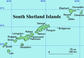
 Map of the South Shetland Islands | |
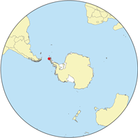
 Location of the South Shetlands | |
| Geography | |
|---|---|
| Location | Antarctica |
| Coordinates | 62°0′S 58°0′W / 62.000°S 58.000°W |
| Area | 3,687 km2 (1,424 sq mi) |
| Highest elevation | 2,025 m (6644 ft) |
| Highest point | Mount Foster |
| Administration | |
| Administered under the Antarctic Treaty System | |
| Demographics | |
| Population | around 500 [citation needed] |
| Ethnic groups | mixed, others |


The South Shetland Islands are a group of Antarctic islands with a total area of 3,687 km2 (1,424 sq mi). They lie about 120 kilometres (65 nautical miles) north of the Antarctic Peninsula,[1] and between 430 and 900 km (230 and 485 nmi) southwest of the nearest point of the South Orkney Islands. By the Antarctic Treaty of 1959, the islands' sovereignty is neither recognized nor disputed by the signatories[citation needed] and they are free for use by any signatory for non-military purposes.
The islands have been claimed by the United Kingdom since 1908 and as part of the British Antarctic Territory since 1962. They are also claimed by the governments of Chile (since 1940, as part of the Antártica Chilena province), and by Argentina (since 1943, as part of Argentine Antarctica, Tierra del Fuego Province).
Several countries maintain research stations on the islands. Most of them are situated on King George Island, benefitting from the airfield of the Chilean base Eduardo Frei.
Sixteen research stations are in different parts of the islands, with Chilean stations being the greatest in number.
- ^ "South Shetland Islands". North Dakota State University. Retrieved 21 August 2009.