Southwest Philadelphia | |
|---|---|
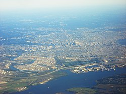
 Southwest Philadelphia as viewed from an airplane | |
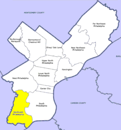
 Southwest Philadelphia, as defined by the Philadelphia City Planning Commission | |
| Country | United States |
| State | |
| County | Philadelphia |
| City | Philadelphia |
| Area | |
• Total | 10.6 sq mi (27 km2) |
| Population (2010) | |
• Total | 123,829 |
| • Density | 5,192/sq mi (2,005/km2) |
| ZIP code | 19142, 19143, 19153 |

Southwest Philadelphia (formerly Kingsessing Township) is a section of Philadelphia, Pennsylvania, United States. The section can be described as extending from the western side of the Schuylkill River to the city line, with the SEPTA. The northern border is defined by the Philadelphia City Planning Commission as east from the city line along Baltimore Avenue moving south along 51st Street to Springfield Ave. It follows the train tracks until 49th Street. From 49th and Kingsessing Ave the line moves east along Kingsessing Ave. The line then moves south along 46th St to Paschall Ave where it jogs to join Grays Ferry where the line runs to the Schuylkill River.[1]
Southwest Philadelphia is also described by the city as being the area south of Baltimore Avenue;[2] at the turn of the 20th century, Baltimore Avenue between 49th and 52nd Streets was known as "The Hub of Southwest Philadelphia" .[3] Historically home to many Irish American neighborhoods, the section now has a large African American and West African immigrant population; a recent nickname is "Little Africa".[4][5][6]
Southwest Philadelphia contains Philadelphia International Airport, oil refineries, and other heavy industries.
The housing stock is diverse with ornate Queen Anne-style twin mansions in the neighborhoods bordering Cedar Park, plainer and simpler styles of twins predominating closer to the airport, and newer rowhouses, many with porches, filling in many neighborhoods.
Less than 1% of Southwest is covered by trees, giving it one of the lowest ratios of shade tree cover in the city.[7]
The Philadelphia Police Department patrols the 12th and 77th districts within Southwest Philadelphia.[8]
- ^ Philadelphia City Planning Commission[usurped]
- ^ "City Archives | Department of Records". City of Philadelphia. September 28, 2022. Retrieved December 21, 2022.
- ^ Cedar Park Neighbors Archived March 18, 2015, at the Wayback Machine
- ^ Risemberg, Annie (February 5, 2018). "How a Corner of Southwest Philly Became "Little Africa"". Slate Magazine. Retrieved December 21, 2022.
- ^ "The Entrepreneur Lifting Up Southwest Philly's "Little Africa"". nextcity.org. Retrieved December 21, 2022.
- ^ Matza, Michael; Duchneskie, John (December 23, 2013). "In Southwest Phila., a 'little Africa' is growing". Philadelphia Inquirer. Retrieved December 21, 2022.
- ^ The Benjamin Franklin Tercentenary
- ^ PPD Online Patrol Districts[usurped], Philadelphia Police Department.
