Back سانت تشارلز (الولايات المتحدة الأمريكية) Arabic سانت تشارلز ARZ سنت چارلز، میزوری AZB St. Charles (Missouri) Catalan Сент-Чарлз (Миссури) CE Saint Charles (kapital sa kondado) CEB St. Charles, Missouri Welsh Saint charles DAG Saint Charles (Missouri) German Saint Charles (Misurio) Esperanto
St. Charles, Missouri | |
|---|---|
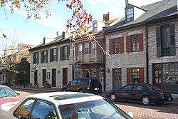
 Historic Main Street | |
 Location in the state of Missouri | |
| Coordinates: 38°47′20″N 90°30′50″W / 38.789°N 90.514°W | |
| Country | United States |
| State | Missouri |
| County | Saint Charles |
| Named for | Charles Borromeo |
| Government | |
| • Mayor | Dan Borgmeyer |
| Area | |
• Total | 25.67 sq mi (66.48 km2) |
| • Land | 25.17 sq mi (65.19 km2) |
| • Water | 0.50 sq mi (1.29 km2) |
| Population (2020) | |
• Total | 70,493 |
| • Density | 2,800.79/sq mi (1,081.40/km2) |
| Demonym | St. Charlesian |
| Time zone | UTC−6 (CST) |
| • Summer (DST) | UTC−5 (CDT) |
| ZIP Codes | 63301-63304 |
| Area codes | 636, 314 |
| FIPS code | 29-64082 |
| Website | www.stcharlescitymo.gov |
Saint Charles (commonly abbreviated St. Charles) is a city in, and the county seat of, St. Charles County, Missouri, United States.[2] The population was 70,493 at the 2020 census, making St. Charles the 9th most populous city in Missouri. Situated on the Missouri River, St. Charles is a northwestern suburb of St. Louis.
The city was founded circa 1769 as Les Petites Côtes, or "The Little Hills" in French, by Louis Blanchette, a French-Canadian fur trader.[3] This former French area west of the Mississippi River was nominally ruled by Spain following France's defeat in the Seven Years' War. France had ceded its eastern territories to Great Britain. St. Charles is the third-oldest city in Missouri. For a time, it played a significant role as a river port in the United States' westward expansion, including trade with Native American tribes on the upper Missouri River. It was the starting point of the Boone's Lick Road to the Boonslick.
St. Charles was settled primarily by French-speaking colonists from Canada in its early days. In 1804 the Lewis and Clark Expedition considered this settlement the last "civilized" stop before they headed upriver to explore the western territory that the United States acquired from France in the Louisiana Purchase.[4]
The city served as the first Missouri capital from 1821 to 1826.[5] It is the site of the Saint Rose Philippine Duchesne shrine.[6]
- ^ "ArcGIS REST Services Directory". United States Census Bureau. Retrieved August 28, 2022.
- ^ "Find a County". National Association of Counties. Archived from the original on May 31, 2011. Retrieved June 7, 2011.
- ^ "Historic Saint Charles". Greatriverroad.com. Archived from the original on August 6, 2011. Retrieved August 2, 2011.
- ^ "Timeline". Stcharlescitymo.gov. Archived from the original on July 21, 2011. Retrieved August 2, 2011.
- ^ "St. Charles: Missouri's First Capitol". Slfp.com. Archived from the original on July 16, 2011. Retrieved August 2, 2011.
- ^ Shrine of St. Philippine Duchesne Archived 2011-07-25 at the Wayback Machine, Academy of the Sacred Heart. Retrieved 2009-10-15.
