Back سانت جوزيف (ميشيغان) Arabic سانت چوزيف (بيرين) ARZ سنت. جوزف، میشیقان AZB Сент-Джозеф (Мичиган) CE Saint Joseph (kapital sa kondado sa Tinipong Bansa, Michigan) CEB St. Joseph, Michigan Welsh Saint Joseph DAG St. Joseph (Michigan) German St. Joseph (Míchigan) Spanish St. Joseph (Michigan) Basque
St. Joseph, Michigan | |
|---|---|
|
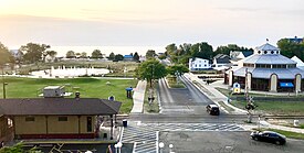
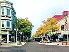
Clockwise from top: Silver Beach, Blossomland Bridge, North Pier Inner Lighthouse, and State Street in downtown St. Joseph | |
| Nickname: St. Joe | |
 Location within Berrien County | |
| Coordinates: 42°05′53″N 86°29′03″W / 42.09806°N 86.48417°W | |
| Country | United States |
| State | Michigan |
| County | Berrien |
| Incorporated | 1834 (village) 1891 (city) |
| Government | |
| • Type | Council–manager |
| • Mayor | Brook Thomas |
| Area | |
| • Total | 4.78 sq mi (12.38 km2) |
| • Land | 3.20 sq mi (8.30 km2) |
| • Water | 1.58 sq mi (4.08 km2) |
| Elevation | 630 ft (192 m) |
| Population (2020) | |
| • Total | 7,856 |
| • Density | 2,452.70/sq mi (947.05/km2) |
| Time zone | UTC-5 (Eastern (EST)) |
| • Summer (DST) | UTC-4 (EDT) |
| ZIP code(s) | 49085 |
| Area code | 269 |
| FIPS code | 26-70960[2] |
| GNIS feature ID | 0636762[3] |
| Website | Official website |
St. Joseph, colloquially known as St. Joe, is a city and the county seat of Berrien County, Michigan. It was incorporated as a village in 1834 and as a city in 1891.[4] As of the 2020 census, the city population was 7,856.[5] It lies on the shore of Lake Michigan, at the mouth of the St. Joseph River, about 90 miles (140 km) east-northeast of Chicago.[6] It is home of the American Society of Agricultural and Biological Engineers.
- ^ "2020 U.S. Gazetteer Files". United States Census Bureau. Retrieved May 21, 2022.
- ^ "U.S. Census website". United States Census Bureau. Retrieved January 31, 2008.
- ^ "St. Joseph". Geographic Names Information System. United States Geological Survey, United States Department of the Interior.
- ^ Coolidge 1906, p. 25.
- ^ "St. Joseph city, Michigan - Census Bureau Profile". United States Census Bureau. Retrieved March 6, 2024.
- ^ "Find a County". National Association of Counties. Archived from the original on May 31, 2011. Retrieved June 7, 2011.


