Back Bae Sain Ffraid Breton Badia de Sant Ffraid Catalan Saint Brides Bay CEB Bae Sain Ffraid Welsh St. Brides Bay German St Brides Bay Basque St Brides Bay NN Saint Brides Bay Swedish
This article is missing information about info about namesake Saint; who is St. Bride? . (March 2020) |

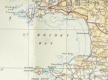
St Brides Bay (Welsh: Bae Sain Ffraid) is a bay in western Pembrokeshire, West Wales.
Either Skomer Island or the mainland extremity of Wooltack Point at the western end of the Marloes Peninsula marks the southern limit of the bay whilst its northern limit is marked by Ramsey Island off St David's Head. The mouth of the bay is about 7 miles (11 km) wide and extends some 10 miles (16 km) eastwards from this line.[1]
- ^ Ordnance Survey 1:50,000 Landranger map sheet 157