Back نهر ستيكين Arabic نهر ستيكين ARZ Стикин Bulgarian Stikine River (suba sa Kanada) CEB Stikine Czech Stikine River Danish Stikine River German Río Stikine Spanish رودخانه استیکین Persian Stikine (fleuve) French
| Stikine River | |
|---|---|
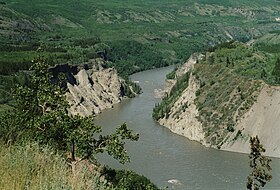
 The Stikine River near Telegraph Creek, British Columbia (2005) | |
 Map of the Stikine River drainage basin | |
| Native name | |
| Location | |
| Country | Canada, United States |
| Physical characteristics | |
| Source | Spatsizi Plateau |
| • location | Stikine Region, British Columbia, Canada |
| • coordinates | 57°14′30″N 128°19′00″W / 57.24167°N 128.31667°W[1] |
| • elevation | 1,830 m (6,000 ft) |
| Mouth | Eastern Passage |
• location | Wrangell, Alaska, United States |
• coordinates | 56°33′50″N 132°24′16″W / 56.56389°N 132.40444°W[1] |
• elevation | 0 m (0 ft) |
| Length | 610 km (379 mi)[2] |
| Basin size | 50,900 km2 (19,700 sq mi)[3] |
| Discharge | |
| • location | Wrangell, AK[3] |
| • average | 1,576 m3/s (55,700 cu ft/s) |
| • minimum | 110 m3/s (3,900 cu ft/s) |
| • maximum | 9,940 m3/s (351,000 cu ft/s) |
| Basin features | |
| Tributaries | |
| • left | Spatsizi River, Klappan River, Klastline River, Mess Creek, Scud River, Porcupine River, Iskut River, Katete River |
| • right | Chukachida River, Pitman River, Kehlechoa River, McBride River, Tanzilla River, Tuya River, Tahltan River, Chutine River, Flood River |
The Stikine River (/stɪˈkiːn/ stick-EEN[4]) is a major river in northern British Columbia (BC), Canada and southeastern Alaska in the United States. It drains a large, remote upland area known as the Stikine Country east of the Coast Mountains. Flowing west and south for 610 kilometres (379 mi),[2] it empties into various straits of the Inside Passage near Wrangell, Alaska. About 90 percent of the river's length and 95 percent of its drainage basin are in Canada.[5] Considered one of the last truly wild large rivers in BC,[6] the Stikine flows through a variety of landscapes including boreal forest, steep canyons and wide glacial valleys.
Known as the "fastest-flowing navigable river in North America,"[7] the Stikine forms a natural waterway from northern interior British Columbia to the Pacific coast. The river has been used for millennia by indigenous peoples including the Tlingit and Tahltan for fishing, hunting and trade. It provided access for fur traders and prospectors during the 1800s and remained an important transportation route until the 1970s, when roads were finally opened to the northern interior. However, most of the Stikine basin remains wilderness, with only a few small settlements; only two bridges, one disused, cross the river along its entire length. The river's salmon run supports large commercial and subsistence fisheries, and its extensive estuary and delta provide habitat for numerous fish and migratory bird species.
Despite its isolation, the Stikine is a destination for recreational activities including boating, hunting and fishing. The river's Grand Canyon, known for its dangerous rapids, has been called the "K2 of white-water challenges"[8] and has only been run by a handful of expert kayakers. During the latter part of the 20th century, numerous large parks and protected areas were established in the Stikine basin, and by the beginning of the 21st century some 60 percent of the basin was under some form of conservation management. However, in recent decades the water quality and natural beauty of the Stikine have been threatened by new energy, transport and mining developments in northern BC.
- ^ a b "Stikine River". Geographic Names Information System. United States Geological Survey, United States Department of the Interior. 1999-12-31. Retrieved 2022-06-10.
- ^ a b J.C. Kammerer (1 September 2005). "Largest Rivers in the United States". U.S. Geological Survey. Retrieved 2022-06-27.
- ^ a b Cite error: The named reference
NWIS Wrangell WY Summarywas invoked but never defined (see the help page). - ^ "Stikine Flats, Tongass National Forest". United States Forest Service. Retrieved 20 January 2024.
- ^ Lehner, B., Verdin, K., Jarvis, A. (2008): New global hydrography derived from spaceborne elevation data. Eos, Transactions, AGU, 89(10): 93–94.
- ^ Peyton 2017, p. ix.
- ^ Devine 2014, p. 87.
- ^ Davis 2015, p. 8.
